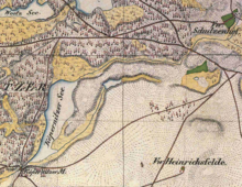
Köpernitzsee
| Köpernitzsee | ||
|---|---|---|
| Geographical location | Brandenburg , Ostprignitz-Ruppin district | |
| Tributaries | Little Rhin, Dunkelseegraben, Fliess from the Karnüppelbrücher | |
| Drain | Little Rhin | |
| Places on the shore | no | |
| Location close to the shore | no | |
| Data | ||
| Coordinates | 53 ° 4 '27 " N , 12 ° 57' 54" E | |
|
|
||
| Altitude above sea level | 57.4 m above sea level NHN | |
| surface | 24.5 ha | |
| length | 1.27 km | |
| width | 320 m | |
| Maximum depth | 2 m | |
The Köpernitzsee is a natural lake in the Stechlin nature reserve . It lies entirely within the boundaries of Heinrichsdorf , a district of the city of Rheinsberg in the Ostprignitz-Ruppin district ( Brandenburg ).
Location and hydrography
The Köpernitzsee is about 5.5 kilometers southeast of Rheinsberg and just under three kilometers west of Dollgow , a district of the municipality of Stechlin . The elongated lake stretches from northeast to southwest. The main inflow and the only outflow is the Little Rhin. The Köpernitzsee is completely surrounded by forest. The southwestern part and the outflow of the Little Rhin is accessible from the Köpernitzer Mühle .
In terms of its natural surroundings, the Köpernitzsee lies in the area of the sand deposits of the Fürstenberg terminal moraine during the Weichselian Cold Age . The sand pourings are locally up to about 50 meters thick and form the upper, unprotected aquifer. The Köpernitzsee is in contact with the aquifer. The lake level is about 57.4 m above sea level. NHN . It has an area of about 24.5 hectares. The maximum depth is around two meters. Due to a drop in the water level of 20 cm, the Köpernitzsee has lost around 4.9 hectares of area since 1912.
In 1950 the Köpernitzsee was classified as Bleisee IV. This means that the lake has visibility depths of two to five meters in summer with very little underwater flora. The fish fauna is dominated by the lead or bream .
The trophic index was given in 1996 as 3.8 (Müller: 3.5), which means that the lake is polytrophic in transition to oligotrophic. It has no stable stratification. According to Müller, the visibility depth was only 0.9 m. Only the rough horn leaf ( Ceratophyllum demersum ) was detected on submerged aquatic plants . Although the lake is completely surrounded by forest and no agricultural areas are in the immediate vicinity, studies in 2004/05 revealed significant anthropogenic influences that were probably already registered above the Dollgower See in the Little Rhin, and finally in the Köpernitzsee arrived.
history
The lake is already mentioned in a document from 1473 (indirectly: the Kopernitz ) and 1530 ( the feltmarcken Kopernitz ... with the Sehe Kopernitz ). In the Schmettauschen map series from 1767/87 it is shown as Köpernitz See . Around 1782 it was called the Copernitzsche See . In the Urmes table sheet 2943 Rheinsberg it is called Köpernitzer See. In the older topographical maps 1: 25,000 it is still called Köpernitzer See. It is not known exactly when the current name Köpernitzsee became established . The name is derived from an old Polish basic form * Kopr'nica to * kopr = dill. The mention of 1473 speaks, according to Reinhard E. Fischer et al. (1996) for naming the place after the lake.
Stechlin nature reserve
The Köpernitzsee is located in the Stechlin nature reserve. Only 15 muscular boats are allowed on the lake. The Köpernitzsee can be fished. However, the lake may only be stocked with carp and lead , for which a care plan had to be drawn up.
literature
- Olaf Mietz (project manager): The lakes in Brandenburg's young moraine region. Part 2. without pagination [245 pages], water cadastre and applied water ecology eV, LUA, public relations department, Potsdam, 1996.
- Reinhard Müller: The Little Rhin - history, structure and water quality. Graduate work for Earning a graduate engineer (FH) of Landscape Management and Nature Conservation of the University of Applied Sciences Eberswalde, Department 2 land use and conservation, Berlin 1998 PDF (abbreviated Below Müller of Small Rhin with corresponding page number)
Individual evidence
- ↑ Müller, Kleiner Rhin, p. 12.
- ↑ Müller, Kleiner Rhin, p. 74, table 6.2.
- ↑ Müller, Kleiner Rhin, p. 17.
- ↑ a b Müller, Kleiner Rhin, p. 35.
- ↑ Uwe Kaboth, Berthold, Rechlin & Gerhard Ginzel: Is there a geogenic risk of salinization in our lakes? Hydrochemical-genetic studies of feeding conditions at lakes in the Stechlin Nature Park. Brandenburg geoscientific contributions, 15 (1/2): pp. 69–79, 2008 PDF
- ↑ Reinhard E. Fischer (co-authors: Elzbieta Foster, Klaus Müller, Gerhard Schlimpert , Sophie Wauer & Cornelia Willich): Brandenburgisches Namenbuch. Part 10: The names of the waters of Brandenburg. Verlag Hermann Böhlaus Successor, Weimar 1996, ISBN 3-7400-1001-0 , p. 145/46.
- ↑ Ordinance on the “Stechlin” nature reserve of November 15, 2002

