Kaputa
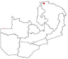
Kaputa is a place with 2754 inhabitants (2006 estimate) in the province of Northern Province (formerly Province of Luapula ) in Zambia . Kaputa is 1250 meters above sea level and is the seat of the administration of the district of the same name with 87,233 inhabitants (2000 census).
economy
Kaputa is one of the least developed districts of Zambia. Kaputa is the seat of the administration of the Kaputa Game Management Area , which adjoins the Nsumbu National Park . Salt is obtained. Kaputa is Zambia northernmost town and is secluded in the mountains between Lake Mweru and Lake Mweru Wantipa . In terms of traffic, it can be reached via Chiengi . Lusaka is 1,200 kilometers away.
politics
When 16,000 refugees streamed across the border to Kaputa during the civil war in the Democratic Republic of the Congo in 1999 , not only the state administration of the district was overwhelmed, but also the efficiency of this place. The refugees were forwarded directly to Mwange in Mporokoso and Kala in Kawambwa , where they could be looked after by the UNHCR .
Infrastructure
There is an unpaved, 1,000-meter-long airstrip in Kaputa, elementary and secondary schools and a hospital.
Social
The maternal mortality rate in the district is the highest in Zambia, 1006 for every 100,000 births.
See also
- For a map with all districts and provinces see: Administrative division of Zambia
Web links
- UNICEF salt project (English)
- Shamans, fled soldiers and lack of state in Kaputa (English)
- Red Cross: photos from the vaccination campaign in Kaputa
Coordinates: 8 ° 31 ′ S , 29 ° 19 ′ E
