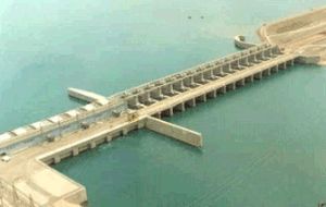
Karkamış barrage
| Karkamış barrage | |||||||
|---|---|---|---|---|---|---|---|
|
|||||||
|
|
|||||||
| Coordinates | 36 ° 52 '13 " N , 38 ° 1' 48" E | ||||||
| Data on the structure | |||||||
| Lock type: | Earthfill dam with a clay core | ||||||
| Construction time: | 1996-2000 | ||||||
| Height above valley floor: | 21.2 m | ||||||
| Height of the structure crown: | 344 m | ||||||
| Building volume: | 2 100 000 m³ | ||||||
| Crown length: | 1 647 m | ||||||
| Power plant output: | 189 MW | ||||||
| Operator: | Elektrik Üretim A.Ş. (EÜAŞ) | ||||||
| Data on the reservoir | |||||||
| Water surface | 28.4 km² | ||||||
| Storage space | 157 million m³ | ||||||
The Karkamış barrage ( Turkish Karkamış Barajı ) is located on the Euphrates in southeastern Turkey 4.5 km above the Syrian border.
The Karkamış barrage located in the provinces of Şanlıurfa and Gaziantep was built in 1996-2000 to generate energy and regulate runoff . Part of the barrier structure is implemented as an earth embankment dam with a clay core . The valley height is 21.2 m, the wall volume 2.1 million m³. The associated reservoir covers 28.4 km² and has a storage volume of 157 million m³. The hydropower plant has six bulb turbines of 32 megawatts each . The standard work capacity is 653 GWh per year. Upstream is the Birecik barrage . The reservoir of the Tishrin dam begins downstream .
Individual evidence
- ↑ a b c d Devlet Su İşleri Genel Müdürlüğü: Gaziantep
- ↑ industcards.com: Hydroelectric Power Plants in Turkey - Akdeniz ( Memento of the original from December 13, 2014 in the web archive archive.today ) Info: The archive link was automatically inserted and not yet checked. Please check the original and archive link according to the instructions and then remove this notice.

