Ataturk Dam
| Ataturk Dam | |||||||||
|---|---|---|---|---|---|---|---|---|---|
|
|||||||||
|
|
|||||||||
| Coordinates | 37 ° 28 '54 " N , 38 ° 19' 3" E | ||||||||
| Data on the structure | |||||||||
| Construction time: | approx. 1983-1992 | ||||||||
| Height above foundation level : | 169 m | ||||||||
| Building volume: | 84.5 million m³ | ||||||||
| Crown length: | 1614 m | ||||||||
| Crown width: | 15 m | ||||||||
| Power plant output: | 2400 MW | ||||||||
| Data on the reservoir | |||||||||
| Water surface | 81,700 ha (817 km²) | ||||||||
| Storage space | 48,500 million m³ | ||||||||
| Catchment area | 92,000 km² | ||||||||
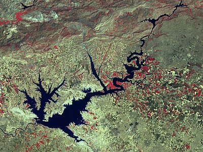
The Ataturk Dam ( Turkish Ataturk Barajı ) on the Euphrates is the first, most important and largest of the 22 dams of the Southeast Anatolia Project (GAP) in Turkey . The reservoir named after Mustafa Kemal Ataturk is about 1.5 times as large as Lake Constance . The dam is the ninth largest in the world according to the bulk volume of the dam , and it is twenty-second in terms of storage space. The information about the date of completion vary depending on the perspective from 1990 to 1995. It has been in operation since 1992.
The dam is used to generate electricity and, via two tunnels near Şanlıurfa, the agricultural irrigation of 1.7 million hectares of land. Almost 10% of Turkey's electrical energy is generated by the hydropower plant .
The Ataturk Dam is - like all new dams - a controversial structure because it has brought with it ecological, economic, cultural and political problems. Important historical and archaeological sites such as B. the ancient metropolis of Samosata were permanently flooded by it. The lake is becoming more and more muddy due to erosion , as the soil from the surrounding landscape is washed into the reservoir. In 1998, the Turkish government therefore decided to reforest the slopes around the Ataturk reservoir, an area the size of the Saarland. Thousands of volunteer students planted trees on the lake shore.
In 1987, Turkey signed an agreement with Syria to allow at least 500 cubic meters of water to flow through the Euphrates per second.
Flooded towns
The reservoir covers a few hundred hamlets and villages. Around 55,000 to 65,000 people had to be resettled in the area beforehand. In 1989, the town of Samosata in Adıyaman Province was also flooded. 2000 inhabitants of this city were relocated to the newly founded village of Samsat (today 4,367 inhabitants).
Satellite image
See also
Web links
- Gigantic dams in southern Turkey ( Memento from June 19, 2009 in the Internet Archive )
- The dam project "GAP"
Individual evidence
- ^ MacQuarrie, Patrick: Water Security In The Middle East Growing Conflict Over Development In The Euphrates - Tigris Basin . The New York Times (English). Accessed January 22, 2014.


