Karur
| Karur கரூர் |
||
|---|---|---|
|
|
||
| State : |
|
|
| State : | Tamil Nadu | |
| District : | Karur | |
| Sub-district : | Karur | |
| Location : | 10 ° 58 ′ N , 78 ° 5 ′ E | |
| Height : | 101 m | |
| Residents : | 214,412 (2011) | |
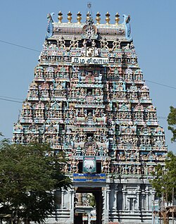
| Gate ( gopuram ) of the Kalyana Pasupatheswar Temple | ||
Karur also Karuvur ( Tamil : கரூர் Karūr ) is a city with almost 215,000 inhabitants in the southern Indian state of Tamil Nadu .
location
Karur is located in the central inland of Tamil Nadu on the Amaravathi , a tributary of the Kaveri , around 75 kilometers west of Tiruchirappalli and around 400 kilometers (driving distance) southwest of Chennai , the capital of the state. The city is conveniently located at the intersection of the railway line from Tiruchirappalli to Erode and the national highway NH 7 from Bangalore to Kanyakumari .
history
The history of Karur goes back to ancient times. The early Chera kings ruled a city called Karur or Vanchi for the first few centuries AD . While it used to be located further west on the Malabar Coast , inscriptions and archaeological finds indicate that the Chera capital is identical to today's Karur. The finds of Roman coins near Karur testify to trade relations with the Roman Empire . After the fall of the early Chera dynasty in the 3rd or 4th centuries, Karur was ruled by the Pandya , Pallava and Chola, and later by Vijayanagar and the Nayaks . In the 18th century, Karur came under the control of Tipu Sultan , king of Mysore . In 1783, the British captured Karur in the Second Mysore War and made it part of British India .
At the end of 2011, the neighboring cities of Inam Karur and Thanthoni and the village ( village panchayat ) Sanapiratti were incorporated into the Municipality of Karur . This increased the population from 71,000 to 214,000.
population
91 percent of Karur's residents are Hindus , 6 percent are Muslims and 3 percent are Christians . As in all of Tamil Nadu, the main language is Tamil, which is spoken by 90 percent of the population as their mother tongue. 5 percent speak Telugu , 3 percent Urdu, and 1 percent Kannada .
economy
The city is the mercantile, craft and service center of a large number of villages in the agricultural area. There are also several smaller industrial companies - including a bus body shop and several weaving mills.
Attractions
The largely modern city offers few sights despite its long history. Exceptions are some temple buildings from the 16th to 18th centuries, including the Kalyana Pasupatheswar Temple, dedicated to the Hindu god Shiva .
In June 2015, a ring was found in the river bed of the Amaravathi River, the writing of which - according to the first experts - could refer to a king of the Pandya period.
literature
Web links
Individual evidence
- ↑ www.census2011.co.in
- ↑ Karur municipality to include Inam Karur, Thanthoni . The Hindu. September 23, 2011.
- ^ Census of India 2011: C-1 Population By Religious Community. Tamil Nadu.
- ↑ Census of India 2001: C-16 City: Population by Mother Tongue (Tamil Nadu), accessed under Tabulations Plan of Census Year - 2001 .

