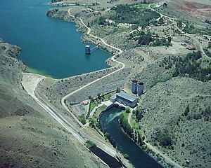
Kesikköprü Dam
| Kesikköprü Dam | |||||||||
|---|---|---|---|---|---|---|---|---|---|
|
|||||||||
|
|
|||||||||
| Coordinates | 39 ° 23 '45 " N , 33 ° 25' 15" E | ||||||||
| Data on the structure | |||||||||
| Lock type: | Earth / stone rubble dam | ||||||||
| Construction time: | 1959-1966 | ||||||||
| Height above the river bed : | 49.1 m | ||||||||
| Building volume: | 900 000 m³ | ||||||||
| Power plant output: | 76 MW | ||||||||
| Data on the reservoir | |||||||||
| Altitude (at congestion destination ) | 785 m | ||||||||
| Water surface | 6.23 km² | ||||||||
| Reservoir length | 25 km | ||||||||
| Storage space | 95 million m³ | ||||||||
The Kesikköprü Dam ( Turkish Kesikköprü Barajı ) is located in Central Anatolia , 20 km west of Kaman on the Kızılırmak River .
The dam, located in the Turkish provinces of Ankara and Kırşehir , was built in 1959–1966 on behalf of the state water authority DSİ for the purpose of energy generation and irrigation . The earth / stone embankment dam is 49.1 m high and has a volume of 900,000 m³. The associated reservoir has a water surface of 6.23 km² and a storage volume of 95 million m³. The dam is used to irrigate 6,600 hectares. The Kesikköprü dam's hydroelectric power station has an installed capacity of 76 megawatts . The standard work capacity is 250 GWh per year. Downstream is the Kapulukaya Dam , about 25 km upstream the Hirfanlı Dam .

