Kidal
| Kidal ⴾⴸⵍ |
||
|---|---|---|
|
|
||
| Coordinates | 18 ° 26 ' N , 1 ° 25' E | |
| Basic data | ||
| Country | Mali | |
| Kidal | ||
| circle | Kidal | |
| ISO 3166-2 | ML-8 | |
| surface | 9913 km² | |
| Residents | 25,617 (2009) | |
| density | 2.6 Ew. / km² | |
| politics | ||
| mayor | Arbakane Ag Abzayack | |
Kidal ( Tuareg ⴾⴸⵍ) is a city (commune urbaine) in northeast Mali . It is located on the southern edge of the Adrar n Ifoghas mountain range and is the main town and namesake of both the Kidal district ( cercle ) and the Kidal region in which it is located.
Administrative division
Kidal extends over an area of 9913 km², which corresponds to a share of 59.7% of the district area. The city consists of the main town Kidal with its four districts Etambar, Center-Ville, Aliou and Anghamali and 43 settlements that are widely scattered over the municipality (Aghabo, Angharous Keyoune, Amassine, Djounhane, Edjerer, Ihinkimane, Iklahane, Imissirika Dane, Infadjadjane, Intadeni, Intibzaz, Kanaye, Takelot, Tamatailalt, Tamainait, Tassik, Tedjeret, Tekankant, Tidjdare, Tidjerfene and others).
Neighboring communities of Kidal are Essouk in the north, Tin Essako in the east, Tidermene in the southeast, Anchawadi in the south and Anefif in the west. The population was 22,858 at the census in May 1996, of which 46.5% were women and 53.5% men, after the 2006 census it was 25,617.
The municipal council (conseil communal), elected for five years in 2009, consists of 27 members. Acting mayor is Arbakane Ag Abzayack, who runs the city with three councilors.
In addition to the local authorities, Kidal is the seat of the regional assembly and the governor, whose official building sits enthroned on a hill above the city.
Facilities
There is a grammar school (Lycee) and four primary schools with an average class size of 70 students. In only eleven of the 43 settlements spread across the city there are the simplest rural schools, so-called “ecoles de brousse”. Other public institutions are the “Maison Luxembourg” cultural center, a youth center and a small hospital. Various military facilities can be found throughout the city .
Both during and after the colonial period, Kidal was the site of a notorious prison for political prisoners , including the later rehabilitated President of the First Republic, Modibo Keïta, who was imprisoned here.
The luxury villas on both sides of the 30 m wide main street are particularly noticeable in the mass of adobe houses that characterize the cityscape.
population
The population consists predominantly of semi-settled Tuaregs . The most influential clans are the Ifoghas and Idnan, and Arabs and a few Songhai also live here .
climate
The lowest average temperature in January is 21 ° C, the highest average temperature in June is 35 ° C. The rainy season lasts from July to September in good years, in bad years there is no precipitation at all.
economy
In addition to traditional nomadic cattle breeding , the black market has become the main source of income since the so-called second Tuareg rebellion in the 1990s. Kidal is an important hub of the cannabis trade between the West African Atlantic coast and Arabia, of cigarette smuggling ("Marlboro Road") as well as the arms trade (mostly residual items from the civil wars of neighboring countries) and human trafficking ( smuggling through poverty refugees on their way to Europe) . Arabs and Tuareg take on the role of the transporter who receives a small share of the profit for each successful shipment; the far greater part goes to Nigerian, Libyan and Lebanese backers.
The arts and crafts - high-quality jewelry and leather goods made by women and blacksmiths - have been suffering from massive overproduction and long transport routes for several years. It is mainly exported to the south of Algeria.
There are two banks in Kidal , the Caisse ADAGH Finance de Kidal , which mainly grants microcredit to women, and the BMS Banque malienne de Solidarité .
Politics and history
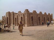
In December 1908 the French colonial officer Betrix decided to set up a military post in the Adrar n Ifoghas massif. In January 1909, Lieutenant Lanceron began building the first fort. In 1917, a second, larger fort was built opposite Wadi Elamba in the city, which was expanded in 1930; this building still exists today.
In addition to the strategically favorable location, the decision in favor of Kidal was primarily due to the fact that the Kidal Tuareg, unlike all other Tuareg tribes, did not offer armed resistance against the invading French and nominally recognized their claim to leadership. The foreign masters, whose main task was the collection of taxes and the "pacification" of the area, quickly realized the advantages of working with the tribal princes and clan chiefs, which increased their importance over time. The head of the Ifoghan clan, the most important of the entire Kidal region, was at times the highest-paid “official” in all of French West Africa.
After Mali's independence in 1961, the young Malian government under its President Modibo Keïta refused to grant the Kidal Tuareg the same degree of autonomy and privileges as the French. A rebellion then began in 1963, but was not supported by other Tuareg tribes. Kidal was not only the starting point for these first, but also for all subsequent Malian Tuareg rebellions. The Malian military responded to the first rebellion with massacres of the population; over a thousand Tuareg died, wells and cattle troughs were poisoned, and cattle were killed. Kidal became a restricted military area, martial law was imposed and all communication lines were cut.
On March 30, 2012, Kidal was taken by the Tuareg, who, reinforced by mercenaries returning from the civil war in Libya , were fighting for their own state , and the Ansar Dine group took power in Kidal. The rule of the Islamists only lasted 11 months, because on January 30, 2013 French troops captured the Kidal airfield and on February 5, 1,800 soldiers from Chad moved into the city itself. In the meantime (spring 2014) the city is largely controlled by Tuareg rebels.
Transport and tourism
Kidal is connected to Anefis, southwest of the city, and Aguel Hoc , to the northwest, via two slopes that branch off the Sahara trade route between the Algerian Tamanrasset and Gao .
Kidal Airport (ICAO code: GAKL) is located on the south-eastern outskirts of the city. The 1,450 m long unpaved runway is neither equipped with radio direction finding nor with an instrument landing system. It was funded by wealthy Saudis who regularly hunt bustards, gazelles and falcons in the region. The airfield can also be used by “avion-taxi”, the charter traffic with small planes.
During the relative calm in the city in the late 1980s, more European Saharan “adventure tourists” were sighted. There are several simple accommodations in Kidal. With the outbreak of civil war-like unrest in the early to mid-1990s, tourism completely collapsed. Following the latest developments (since 2006), the Federal Foreign Office urgently warns against traveling to the region.
See also
swell
- Annuaire statistique 2006 de la region de Kidal, Plan de Securite Alimentaire - Commune Urbaine de Kidal 2007–2011
Individual evidence
- ↑ INSTAT: Results of the 2009 census (PDF; 686 kB, web archive)
- ↑ a b Ousmane Koné: Mairie de Kidal: rejet de la requête de report de l'Adema: Une nouvelle équipe, sans “les abeilles”, est investie. Le Hoggar, May 26, 2009 ( Memento of the original from October 16, 2011 in the Internet Archive ) Info: The archive link was inserted automatically and has not yet been checked. Please check the original and archive link according to the instructions and then remove this notice. accessed on October 6, 2010
- ↑ Is Mali's coup doomed? In: BBC News . April 1, 2012, accessed April 2, 2012 .
- ↑ Mali Tuareg, Islamists still deadlocked over breakaway state ( Memento from June 5, 2012 in the Internet Archive )
- ↑ French troops reach Kidal. In: FAZ . January 30, 2013, accessed February 8, 2013 .
- ↑ Mali: 1,800 soldiers from Chad secure former Islamist strongholds. In: Spiegel Online . February 5, 2013, accessed February 8, 2013 .
- ↑ Alexander Göbel, Journey to the Most Dangerous Place in West Africa , Deutschlandfunk, March 8, 2014
- ↑ Kidal Airfield in Mali on Google Maps ( 18 ° 26 ′ 6 ″ N , 1 ° 25 ′ 23.9 ″ E )


