Kilsbach (Gersprenz)
| Kilsbach | ||
|
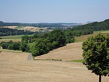
Kilsbach near Kilsbach |
||
| Data | ||
| Water code | DE : 247617118 | |
| location |
Odenwald
|
|
| River system | Rhine | |
| Drain over | Gersprenz → Main → Rhine → North Sea | |
| source | in the Odenwald northwest of the hamlet of Kilsbach 49 ° 45 ′ 23 ″ N , 8 ° 54 ′ 0 ″ E |
|
| Source height | 255 m above sea level NHN | |
| muzzle | south of Brensbach in the Gersprenz Coordinates: 49 ° 46 '7 " N , 8 ° 52' 37" E 49 ° 46 '7 " N , 8 ° 52' 37" E |
|
| Mouth height | 173 m above sea level NHN | |
| Height difference | 82 m | |
| Bottom slope | approx. 46 ‰ | |
| length | approx. 1.8 km | |
The Kilsbach is an almost two kilometer long right and southeast tributary of the Gersprenz .
geography
course
The Kilsbach rises in the northern Odenwald between the farms that make up the hamlet of Kilsbach .
Its main direction of flow is the northwest. It flows right past the Wingertsberg . Coming from the forest smithy, a nameless brook flows to him.
The Kilsbach flows through the Bruch von Brensbach nature reserve and finally flows south of Brensbach into the Gersprenz .
Gersprenz river system
Renaturation
The Kilsbach has been drained in the estuary and its river bed has been remodeled in a natural way. The drainage ditches were closed to prevent the reeds and alluvial forests from drying out .
Web links
- Gersprenz waterfront neighborhood (PDF file; 5.05 MB)
- The Brensbach Rift (PDF file; 1.03 MB)

