Kilwa Kisiwani
| Kilwa Kisiwani and Songo Mnara ruins | |
|---|---|
|
UNESCO world heritage |
|

|
|
| The fort on the banks of Kilwa Kisiwani |
|
| National territory: |
|
| Type: | Culture |
| Criteria : | (iii) |
| Reference No .: | 144 |
| UNESCO region : | Africa |
| History of enrollment | |
| Enrollment: | 1981 ( session 5 ) |
| Red list : | 2004-2014 |
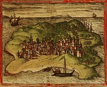
The ruins of the former port city of Kilwa Kisiwani ( Swahili , "Kilwa on the island", historical Portuguese spelling Quiloa ) are located about 280 km south of Dar es Salaam in the Lindi region in the Kilwa district in Tanzania . It is located on an island that is separated from the mainland with the main town Kilwa Masoko by an inlet of the Indian Ocean that is only 1.5 km wide . In 2007 around 500 people lived in simple mud huts on the island.
Significant historical buildings in Kilwa are two mosques and a large town house. In the 13th to 16th centuries, Kilwa was an important trading center for the Indian trade for gold , silver , pearls , perfumes , Arabic earthenware , Persian ceramics and Chinese porcelain . It was the most important city on the east coast of Africa in the 13th and 14th centuries.
The city belongs together with Songo Mnara since 1981 to UNESCO - World Heritage Site . From 2004 to 2014 it was included in the Red List of World Heritage in Danger due to the lack of any measures to stop the ruins from decaying .
history

The history of the city is known from the Kilwachronik , which was written around 1520. After that, the city was founded in 975 by the Persian Ali ibn Hasan from Shiraz , who founded the Shiraz dynasty. Kilwa has also minted its own coins since the beginning of the 12th century. The Yemeni Mahdali dynasty, whose first ruler was al-Hasan bin Talut , ruled here from around 1300 . Under his grandson Al-Hasan ibn Sulaiman Abu'l-Mawahib (approx. 1310-1333), the city experienced its greatest heyday and received numerous important buildings. In 1331 Ibn Battuta visited the city. His travelogue is the first and only surviving source for centuries. At the end of the 14th century, however, there was some decline. From 1375 no more coins were minted and the great mosque slowly fell into disrepair. At the beginning of the 15th century, however, a few more mosques were built and the city's great mosque was rebuilt.
In 1505 the city came under Portuguese control after it was conquered and sacked by Francisco de Almeida , but this only lasted until 1512. The city partially recovered, but then fell into disrepair in the 17th century. It only experienced a further boom in the late 18th century through the slave trade and in 1784 came under the rule of the Busaidi dynasty of Oman . The set up a Liwali (governor), whose official seat was later moved to Kilwa Kivinje , which also replaced the island town as a marketplace and port for the slave trade.
Preserved ruins
Husuni Kubwa
The Husuni Kubwa palace was built or at least greatly expanded by Sultan al-Hasan ibn Sulaiman Abu'l-Mawahib (around 1310-1333). In its time it was the largest stone building south of the Sahara . The palace consisted of several large courtyards, in one of which there was a large bathroom with an octagonal basin. Many rooms had vaults and the walls were decorated with friezes. There was also a small mosque in the palace . Three inscriptions were found in the palace, one of which mentions Sultan al-Hasan ibn Sulaiman, who also built a mosque in Kilwa. The remains of his buildings are located about 1.5 kilometers outside the city, directly by the sea.
Gereza
The first fortress was likely built in the late 15th century. The current fortress was built in the early 19th century by Arabs from Oman on the site of the first fortress and using some remains of the wall - probably on the orders of the Imam of Muscat . The name Gereza comes from its temporary use as a prison. The square building with two round towers and a rectangular tower, with several crew rooms in between, was preserved. The historic wooden gate was removed in February 2012 and is now located in the National Museum in Dar-es-Salaam .
Great mosque
It is the largest sacred building of its time on the African coast of the Indian Ocean. Started around the year 1050 by Ali bin Al Hasan , the first sultan of Kilwa, it was significantly expanded and embellished by Sultan Al Hasan bin Suleiman around 1320. Small changes and renovations took place in the 15th and 18th centuries. The 16 domes rest on 30 columns and cover a floor space of just over 100 m².
Makutani palace
To the west of the mosque is this palace from the 16th century. This was built after the Portuguese attack and is architecturally simpler than the Husuni Kubwa.
Movies
- Adventure Archeology: The Forgotten History of the Swahili. 27-minute film documentary by Agnès Molia, Raphaël Licandro for Arte (France 2018)
literature
- Neville Chittick: Kilwa: An Islamic Trading City on the East African Coast , 2 vols, Nairobi: British Institute in Eastern Africa 1974
Web links
- Entry on the UNESCO World Heritage Center website ( English and French ).
- Kilwa on archnet
Coordinates: 8 ° 57 ′ 35 ″ S , 39 ° 29 ′ 46 ″ E


