
Kimstad
| Kimstad | ||||||
|
||||||
| State : | Sweden | |||||
| Province (län): | Östergötland County | |||||
| Historical Province (landskap): | Östergötland | |||||
| Municipality : | Norrkoping | |||||
| Coordinates : | 58 ° 33 ' N , 15 ° 58' E | |||||
| SCB code : | 1128 | |||||
| Status: | Crime scene | |||||
| Residents : | 1469 (December 31, 2015) | |||||
| Area : | 1.7 km² | |||||
| Population density : | 864 inhabitants / km² | |||||
| List of perpetrators in Östergötland County | ||||||

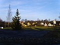
Kimstad is a place ( Tatort ) in the Swedish province of Östergötland County and the historical province of Östergötland . The place is on the river Motala röm between Linköping and Norrköping . It is part of the municipality of Nörrköping .
traffic
The Södra stambanan runs through Kimstad and the Kimstad – Finspång railway branches off , which formerly belonged to the Norra Östergötlands Järnvägar . Kimstad is located on Länsväg 215, the European route 4 leads past the village about three kilometers away.
photos
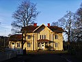
railway station
At the train station

church

Runestone


Individual evidence
- ↑ a b Statistiska centralbyrån : Land area per Tatort, folkmängd and invånare per square kilometer. Vart femte år 1960 - 2015 (database query)
Perpetrator: Åby | Berga | Djurön | Eksund | Graversfors | Herstadberg | Kimstad | Krokek | Kvarsebo | Lindö | Ljunga | Marbystrand | Norrköping | Norsholm | Öbonäs | Östra Husby | Simonstorp | Skarblacka | Svärtinge
Småorter: Arkösund | Backerslund | Branttorp och Lundsbo | Getå | Göstadberg | Gods | Gruvstugan | Hagsätter (Kvillinge) | Hagsätter (Västra Husby) (part) | Hollstad | Hultsbruk | Kättinge | Kopparbo | Lindö | Loddby | Ludden | Lundby | Markgärdet | Meme | Östra Ny | Östra Stenby | Ryssnäs | Skärkind | Stora Sidus | Styrstad and Gräsnäs | Sund | Svärdstorp och Erikstorp | Svärtinge gård | Tåby | Tallebo | Ugglebo | Vånga | Ystad Fågellund