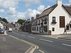
Kirkoswald (South Ayrshire)
|
Kirkoswald Scottish Gaelic Cill Osaill |
||
|---|---|---|
| Main street of Kirkoswald | ||
| Coordinates | 55 ° 20 ′ N , 4 ° 46 ′ W | |
|
|
||
| administration | ||
| Post town | MAYBOLE | |
| ZIP code section | KA19 | |
| prefix | 01655 | |
| Part of the country | Scotland | |
| Council area | South Ayrshire | |
| British Parliament | Ayr, Carrick, and Cumnock | |
| Scottish Parliament | Carrick, Cumnock and Doon Valley | |
Kirkoswald is a village in the Scottish Council Area South Ayrshire or in the traditional county of Ayrshire . It is located about eight kilometers northeast of Girvan and 13 kilometers southwest of Ayr not far from the coast of the Firth of Clyde .
history
The church history at this place supposedly goes back to the year 633, when the Northumbrian King Oswald fought a battle nearby. Previously, he committed himself to building a church in this place in the event of a victory. The name of the village Kirkoswald ("Oswaldskirche") is derived from this. To this day, if this building was ever built, it has completely disappeared. The predecessor of today's church was built around 1200 and can be found as a ruin in the churchyard.
Today's Kirkoswald Parish Church was built in 1677. At the same time, the architect Robert Adam was working on the nearby Culzean Castle . Based on stylistic features, it is assumed that Adam was at least involved in the design of the church. It would be Adam's only church building. The parish owns a medieval baptismal font, in which Robert the Bruce was supposedly baptized.
The ancestors of the writer Robert Burns , who lived in Kirkoswald for a while, are buried in the old churchyard. Likewise, the real role models of various characters from Burns' works. The character Souter Johnnie in Burns 'most famous poem Tom o' Shanter is based on the real person John Davidson . Davidson was a shoemaker in Kirkoswald and lived in a building that is now a listed building as Souter Johnnie's Cottage .
After 296 inhabitants were counted in Kirkoswald in 1961, only 196 people lived there at the time of the 1991 census survey.
traffic
Of Glasgow to Portpatrick leading A77 is the main thoroughfare of Kirkoswald. West, near the coast also extends over the Ayr and Galston according Waterside leading A719 .
Individual evidence
- ^ Entry in the Gazetteer for Scotland
- ↑ a b Information about the church building ( Memento from May 29, 2014 in the Internet Archive )
- ↑ Entry on Kirkoswald Parish Church in Canmore, the database of Historic Environment Scotland (English)
- ↑ Entry on Souter Johnnie's Cottage in Canmore, the Historic Environment Scotland database
- ^ Information in the Gazetteer for Scotland

