Little Lukow
|
Little Lukow
City of Penzlin
Coordinates: 53 ° 32 ′ 2 ″ N , 13 ° 2 ′ 1 ″ E
|
|
|---|---|
| Height : | 56 m |
| Incorporation : | January 1, 2011 |
| Postal code : | 17217 |
| Area code : | 03962 |
Klein Lukow is a district of the town of Penzlin in the Mecklenburg Lake District in Mecklenburg-Western Pomerania (Germany).
geography
Klein Lukow is located in the Mecklenburg Lake District , west of the Tollensesees . The area is characterized by fields, forests and the 6.3 hectare Klein Lukower See . The city of Penzlin is about six kilometers from Klein Lukow.
history
The place name Lukow indicates an originally Slavic settlement and could be derived from the old Slavic locator Luka, meaning "place of Luka". In the period of German colonization of the East often built next to the existing and later Small An in-close proximity named place large reflect each. Klein Lukow was first mentioned in old documents from the city of Penzlin around 1230. At the beginning of the 14th century, Groß Lukow is recorded in church records. Small and large Lukow developed separately through the Klein Lukower See, which lies between the two places . The former district of Carlstein to the north developed out of a dairy and has been part of the community since the end of the 18th century. Only the remains of an English landscape park have survived from the former manor house in Groß Lukow. The manor house, a two-storey, 13-axis building with a central risalit , was built according to plans by the architect Paul Korff .
From 1885 to 1945 Klein Lukow was on the railway line from Neubrandenburg to Kargow .
On July 1, 1950, the previously independent community Groß Lukow was incorporated.
The formerly independent community of Klein Lukow with its districts Carlstein, Klein Lukow and Groß Lukow had 247 inhabitants on December 31, 2009 on an area of 14.13 km². On January 1, 2011, it was incorporated into the city of Penzlin.
Attractions
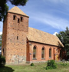
- Listed church in Groß Lukow with a tower from the 15th century and the nave from 1866
Transport links
The federal highway 192 passes south. The next larger train stations are in Neubrandenburg and Neustrelitz .
Web links
swell
- ^ Paul Kühnel: The Slavic place names in Meklenburg. In: Yearbooks of the Association for Mecklenburg History and Archeology. Vol. 46, 1881, ISSN 0259-7772 , pp. 3-168, here p. 88, ( digitized version ).
- ^ Area changes in Mecklenburg-Western Pomerania. January 1 to 19, 2011 (PDF; 60 kB) State Statistical Office MV
