
Geghard monastery
| Geghard Monastery in the Upper Azat Valley | |
|---|---|
|
UNESCO world heritage |
|

|
|
| View from the west |
|
| National territory: |
|
| Type: | Culture |
| Criteria : | (ii) |
| Surface: | 2.7 ha |
| Buffer zone: | 40 ha |
| Reference No .: | 960 |
| UNESCO region : | Asia and Pacific |
| History of enrollment | |
| Enrollment: | 2000 (session 24) |
The Geghard Monastery ( Armenian Գեղարդի վանք Geghardi wank ) is an Armenian monastery in a gorge on the upper reaches of the Azat in the province of Kotajk . The rooms, which are partly carved into the rock, or the use of caves are characteristic. Peculiarities of Armenian architecture such as Gawit or Chatschkar can also be found here. The monastery is one of the most important testimonies of the Armenian Apostolic Church and was included in the UNESCO World Heritage List in 2000 .
history
_monastery_Morier.png)
The foundation of the monastery in the 4th century AD on the site of a pagan spring is attributed to Saint Gregory , the patron saint of the Armenian Apostolic Church . It was destroyed by the Arabs in the 9th century, so no buildings from this period have survived.
The reconstruction began in 1215. According to an inscription on the main church, the brothers Ivane and Zakhare are considered to be the builders who founded the Zakharjan dynasty, who ruled Armenia in the 12th century as vassals of the kings of Georgia . In the middle of the 13th century the monastery came into the possession of the noble family Proschjan, who laid their burial there in the rock.
In 1679 the monastery was badly damaged by an earthquake. It remained deserted and was only settled again by some monks from Echmiadzin after the conquest of Armenia by Russia . It was only restored for tourism in the 20th century.
Surname
The monastery was originally called Ajrivank , which means cave monastery. The name Geghardavank ( Armenian Գեղարդավանք ), attested from the 13th century, means "Monastery of the Holy Lance". This means a relic of the Holy Lance , which the apostle Thaddäus is said to have brought into the country and which was kept in the monastery. Today it is in the Etchmiadzin Cathedral Museum .
description

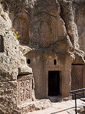
The monastery complex is closed on its south and east sides by buildings (13). On its west side it borders on a rock wall, south of which is the main gate (14). A smaller entrance (15) is on the east side. On its higher north side, the monastery is protected by a wall (12).
The main church (Kathogike, No. 2) of the monastery is consecrated to Our Lady . It is an east-facing cross - domed church with four corner chapels and a drum with a tent roof . Its vestibule (Gawit, No. 3) is much larger than the church itself. Four massive pillars support the arches that divide the Gawit into nine sections. There is a light opening above the larger central square.
To the north of the Kathogike and their gawits, further churches and gawits are driven into the rock. A first rock church, called Avazan Church, is accessible from the north-west corner of Gawit. It was built in 1240 as an extension of a cave that contained a spring. It has an almost square floor plan in which a square is inscribed by columns and arches. The dome has a stalactite vault borrowed from Islamic architecture. In the church there is the water basin (Avazan), in which the water of the spring, which is considered miraculous, is collected.
From the northeast corner of the Gawits one arrives at the Zhamatoun, also called Proschjan crypt, a kind of Gawit, which is used for burial. It was carved into the rock in 1283, as was the rock church of the Proschjan family behind it. A staircase and an approximately 2 m wide and 10 m long corridor lead from the west side of the complex to the upper Gawit, which is also used for burial. It was built by Prince Josch in 1288 as a crypt for his wife above the other cavities. In the northeast corner of the monastery, several small rock chapels, which can be reached via a staircase, are carved into the rock.
photos

Kathogike

South portal

Church interior

Gawit
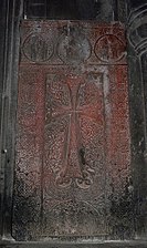
Khachkar


Avazan Church

Zhamatoun

Church of Proshyan

Upper Gawit
Rock chapel


World Heritage

The monastery was registered as a cultural heritage site in the UNESCO World Heritage List in 2000 based on a resolution of the 24th session of the World Heritage Committee under the name of Geghard Monastery in the Upper Azat Valley . The reason for the entry states, among other things:
Geghard Monastery and the upper Azat Valley contain a number of churches and tombs, most of which are cut into the adjoining rocks, illustrating Armenian medieval architecture at its height. The complex of medieval buildings is located at the entrance to the Azat Valley in a landscape of great natural beauty. High cliffs surround the complex on the north side, while the defensive wall surrounds the rest.
The entry was made on the basis of criterion (ii).
(ii): The Geghard Monastery, with its remarkable rock-hewn churches and tombs, is an exceptionally well-preserved and complete example of medieval Armenian monastery architecture and decorative arts, with many innovative features that profoundly influenced subsequent developments in the region.
The protected area of the world heritage site has an area of 2.7 hectares and includes the area of the monastery up to the river. It is surrounded by a buffer zone with an area of 40 ha, which extends on both sides of the river.
There is a UNESCO partnership with the Lorsch Abbey in Hesse.
literature
- Jasmine Dum-Tragut : Geghard . In: Armenia . 8th updated and expanded edition. Trescher Verlag, Berlin 2017, ISBN 978-3-89794-385-8 , pp. 252-259 .
Web links
- Geghard Monastery in the Upper Azat Valley on the UNESCO World Heritage Center website ( English and French ).
- The Geghard Monastery on the website of the University of Innsbruck
- Geghard Monastery at armeniapedia (English)
- Geghard Monastery Architectural Complex at Armenica.org (English)
- Geghart In: Armenian Studies Program. California State University, Fresno (English)
Individual evidence
- ^ A b c d Monastery of Geghard and the Upper Azat Valley. UNESCO World Heritage Center, accessed August 25, 2017 .
- ^ Cathedral Museum. In: www.armenianchurch.org. Armenian Apostolic Church , accessed November 20, 2017 .
- ↑ The numbers refer to the illustration with the floor plan.
- ↑ Official name English Monastery of Geghard and the Upper Azat Valley , French Monastère de Gherart et la Haute vallée de l'Azat , German name according to the World Heritage List. In: www.unesco.de. Retrieved November 16, 2017 .
- ↑ Decision: CONF 204 XC1. In: whc.unesco.org. UNESCO World Heritage Center, accessed November 18, 2017 .
- ^ Monastery of Geghard and the Upper Azat Valley - Maps. In: whc.unesco.org. UNESCO World Heritage Center, accessed November 20, 2017 .
- ^ Hermann Schefers: International Meeting Point. Project Armenia. (No longer available online.) In: Monastery Lorsch website. September 9, 2001, archived from the original on September 6, 2012 ; Retrieved March 28, 2012 . Info: The archive link was inserted automatically and has not yet been checked. Please check the original and archive link according to the instructions and then remove this notice.

Coordinates: 40 ° 8 ′ 25.7 ″ N , 44 ° 49 ′ 6.9 ″ E