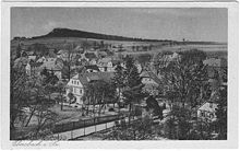
Klunst
The Klunst is a former 440.0 m high mountain in Ebersbach / Sa. which is mined today in the quarry. It lies between the Ebersbach – Löbau railway line and the Ebersbacher Buschmühl houses and overlooks the Bleichewassertal by 60 to 80 m.
The mountain name contains the same root word as that of the Steinklunsen between Oppach and Beiersdorf . In dialect, Klunst means "fissured rock".
geology
The Klunst is made up of a lamprophyre duct. This has the shape of a lens and is up to 150 m wide. Such dikes are common in the Lusatian granodiorite massif . However, nowhere do they reach this power as with the Klunst. The corridors run in the eastern part of the granodiorite massif from northeast to southwest and in the western part from northwest to southeast. South of Löbau is the transition area from one direction to the other, where corridors extend from north to south. The one at the Klunst is one of them. Günter Möbus (1959) states in a study of the tectonics of the dike rocks that the opening of the fissures and thus the formation of the dikes “can best be explained by a bulge-like bulge”, which occurred after all granodioritic rocks had formed. During this process, the cracks tore open radially. Of these, over 1200 are known today in Upper Lusatia that contain lamprophyric rock. The lamprophyres are known in older geological literature as diabase , popularly also as green stone , due to their petrographic training . Exact investigations have shown that the Lusatian lamprophyres are very rich in varieties, which is why they received various geological names, such as Spessartite, Kersantite and others. The minerals plagioclase , augite , hornblende , biotite as well as oxidic and sulfidic ore are mainly involved in their structure . Copper ore and galena could be recovered from the Klunst in insignificant amounts. Since their rock has been continuously mined since the beginning of the 20th century, the former reef-like summit cliffs completely fell victim to the quarry operation.
The following (collect driven interesting) minerals were found in the Klunst: Allanit - (Ce), Ankerit , azurite , calcite , Cerussite , chabazite Ca, chalcopyrite , covellite , epidote , galena , garnet ( Andradite ), hematite , Heulandit Ca, ilmenite , Laumontite , magnetite , malachite , magnesio hornblende , muscovite , phlogopite , plagioclase ( albite ), prehnite , pyrite , pyromorphite , pyrrhotite , quartz ( rock crystal ), sphalerite , stilbit- Ca, titanite and tourmaline .
History of the quarry
The Raumbusch forest district and the adjoining Klunst to the south belonged to the town of Zittau until 1921. In 1902 the company leased part of the mountain (the southern slope of the highest peak) to a private quarry. The breakdown starts very small. As early as 1910, the Humboldtverein, the Landesverein Sächsischer Heimatschutz and the Ebersbach municipal council objected to the disfigurement of the landscape caused by the quarry, as the peaks also represented geologically and geomorphologically interesting natural structures.
In 1914 the Ostdeutsche Hartsteinwerke took over the quarry. A dismantling contract is concluded with Zittau until 1940, although numerous objections have already been received. Hermann Andert , together with other German scientists, began a desperate struggle to save Klunst. Contracts were made and broken by the Ostdeutsche Hartsteinwerke until the first and highest rock peak was blown away.
On January 21, 1937, the second summit was registered as a nature reserve in the German Reich's natural monument book. In 1940 the mining contract was extended by Zittau. On August 7, 1945, the Ostdeutsche Hartsteinwerke submitted an application to annul the nature reserve. It is rejected, the Reich Nature Conservation Act continues to apply. On August 4, 1954, it was replaced by the GDR's 1st Nature Conservation Act. The quarry operation, however, gains the upper hand. Against the will of the citizens of Ebersbach, the nature reserve was canceled on September 21, 1956 by an official announcement in the Sächsische Zeitung.
Like the Lamprophyrbruch near Niederfriedersdorf , which has now been filled , the one at the Klunst belonged to VEB Lausitzer Granit Demitz-Thumitz. The material, broken on two soles, was loaded onto dump trucks by grippers and brought to the crusher and classifying plant. In 1968 a technical system from France was built in place of an old one. Their annual capacity at that time was around 240,000 t. In addition to gravel (35.5–80 mm), four types of grit (2.5–5 mm, 5–8, 8–12.5, 12.5–25 mm) and sand (up to 0.3 mm) were extracted. Since 1967 the braking system from the crusher to the loading device on the Ebersbach-Löbau railway line was shut down, trucks have been transporting the broken material to Ebersbach station.
After 1990 the quarry should be closed and used as a circular waste dump. Conservationists from Ebersbach start a signature campaign with almost 3000 signatures against it.
ProStein GmbH & Co. KG (founded: March 1, 2000) took over the quarry operations.
Since October 2007, Ebersbach has been loaded again using a new rail loading system. Building construction and road construction companies receive grit and sand from the Ebersbach train station, which are used as aggregates.
swell
- Between Strohmberg, Czorneboh and Kottmar (= values of our homeland . Volume 24). 1st edition. Akademie Verlag, Berlin 1974.
- Original documents from the NABU district association Löbau eV
Individual evidence
- ^ A b Wolfram Lange: The "Klunst" quarry in Ebersbach / Saxony. In: the opening. Vol. 63, March - June 2012, pp. 073-084. Heidelberg.
Coordinates: 51 ° 0 ′ 55.3 " N , 14 ° 35 ′ 27.1" E


