
Knjase-Volkonskoye
| Village
Knjase-Volkonskoye
Князе-Vолконское
|
||||||||||||||||||||||||||||
|
||||||||||||||||||||||||||||
|
||||||||||||||||||||||||||||


Knjase-Wolkonskoje ( Russian Кня́зе-Волко́нское ) is a village (selo) in the Khabarovsk region ( Russia ) with 9155 inhabitants (as of October 14, 2010).
geography
The place is about 30 km as the crow flies east of the regional administrative center of Khabarovsk , which is also the administrative seat of the Rajons Khabarovsk , to which the village belongs. It is located on the right bank of the right Sita tributary of the Amur , immediately below the confluence of the Obor .
Knjase-Volkonskoye is the seat of the rural municipality Knyase-Volkonskoye selskoje posselenije, which also includes the village of Blagodatnoye.

View of the place

The Sita with Knjase-Volkonskoye

Blagodatnoye Lake near Knyase-Volkonskoye, a flooded gravel pit
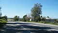
Regional road R454 near Knyase-Volkonskoye


history
The village was founded in 1903 by resettlers from the Tambov governorate and named after Prince Michail Wolkonski (1832-1903, Russian Knjas Wolkonski ), participant in the Russian Amur expedition from 1851 to 1855 under Gennadi Nevelskoi and Nikolai Muravyov-Amursky and later statesman.
To the north of the village, a larger site for the Soviet Army and now the Russian Armed Forces was built. Its previously closed housing estate was connected to Knjase-Volkonskoye in the 1990s, which more than tripled its population.
Population development
| year | Residents |
|---|---|
| 2002 | 9206 |
| 2010 | 9155 |
Note: census data
traffic
Knjase-Volkonskoye is located on the Vostok trunk road coming from Khabarovsk, which is also the R454 regional road on this section . The road splits a few kilometers east of the village: while the Vostok road turns south towards Nakhodka , the R454 heads north-east to Komsomolsk am Amur .
Individual evidence
- ↑ a b Itogi Vserossijskoj perepisi naselenija 2010 goda. Tom 1. Čislennostʹ i razmeščenie naselenija (Results of the All-Russian Census 2010. Volume 1. Number and distribution of the population). Tables 5 , pp. 12-209; 11 , pp. 312–979 (download from the website of the Federal Service for State Statistics of the Russian Federation)
Web links
- Local government website (Russian)