Cobra (Vyatka)
|
Cobra Кобра |
||
|
|
||
| Data | ||
| Water code | RU : 10010300212111100030641 | |
| location | Komi Republic , Kirov Oblast ( Russia ) | |
| River system | Volga | |
| Drain over | Vyatka → Kama → Volga → Caspian Sea | |
| source |
North Russian ridge 60 ° 12 ′ 43 ″ N , 50 ° 7 ′ 18 ″ E |
|
| Source height | 188 m | |
| muzzle | at Nagorsk in the Vyatka coordinates: 59 ° 19 '43 " N , 50 ° 52' 32" E 59 ° 19 '43 " N , 50 ° 52' 32" E |
|
| Mouth height | 127 m | |
| Height difference | 61 m | |
| Bottom slope | 0.19 ‰ | |
| length | 324 km | |
| Catchment area | 7810 km² | |
| Drain |
MQ |
55 m³ / s |
| Left tributaries | SOS | |
| Right tributaries | Suran, Fyodorovka | |
| Small towns | Nagorsk | |
|
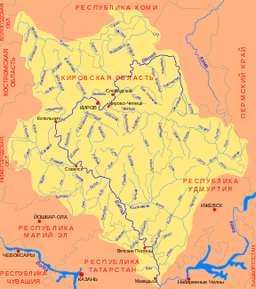
Cobra (Кобра) in the catchment area of the Vyatka |
||
The cobra ( Russian Кобра ) is a right tributary of the Vyatka in northern Russia .
The cobra has its source on the northern Russian ridge in the Komi Republic . It flows in an arc, initially to the east, south and west, and then again to the south. It crosses the border to the southern Kirov Oblast . Finally, at Nagorsk , it flows into the upper reaches of the Vyatka, a right tributary of the Kama .
The cobra is 324 km long. It drains an area of 7810 km². The mean discharge is 55 m³ / s. The most important tributary of the Kobra is the Fyodorowka , which flows into the river at 51 km from the right.
