
Cobblestones (calden)

The cobblestones , also just cobblestones and popularly called the Koppensteine , are an at about 310 m above sea level. NHN located natural monument (no. 6.33.126) in the area of the North Hesse Kassel district commune in Calden .
Geographical location
The cobbles are located in the West Valley Uffelner the Caldener district Furstenwalde , about 500 m west of the village, on a in a grove at the track Kopfensteiner way lying hill . The Nebelbeeke coming from the Dörnberg massif from the Scheuermannsgrund flows west past in a south-north direction . Directly south past the hilltop, the farm road, which begins at the Kopfsteiner Weg and leads south to the Hohe Dörnberg massif, crosses in an east-west direction from the 815.5 m long Zierenberg tunnel , the Volkmarsen – Vellmar-Obervellmar railway line - with a nearby stop in Fürstenwald and connection to Kassel .
Since around 2014, the summit with the two stones has been a southern part of the new Fürstenwald open land area , which was created as a compensation measure for the expansion of the airport in Calden.
description
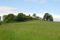
The cobblestones consist of two up to five meters high basalt columns, standing chimneys , in which the softer material surrounding the tertiary basalt - such as shell limestone (sea deposits) and tuff - was and is being eroded away.
gallery
- Koppensteine near Fürstenwald

The cobblestones from the east
The cobblestones west of Fürstenwald
The cobblestones from the south


See also
Individual evidence
literature
- Topographical leisure map of the Habichtswald / Reinhardswald Nature Park (TF 50-HR; 1: 50,000; 2003), publisher: Hessisch-Waldeckischer Gebirgs- und Heimatverein e. V. and Hessian Land Surveying Office, ISBN 3-89446-319-8
- Habichtswald cycle and hiking map , from Kassel to Twiste and Edersee (1: 33.333), publisher: Geo-Verlag (Kaufungen)
Web links
- Natural monument cobblestones . Map TK 1: 25,000 In: State History Information System Hesse (LAGIS).
Coordinates: 51 ° 22 '48.1 " N , 9 ° 21' 4.6" E