
List of natural monuments in Calden
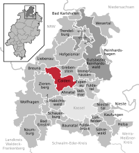

The list of natural monuments in Calden called on the municipality Calden in the district of Kassel, in Hesse located natural monuments . There are currently 5 trees, as well as 6 extensive natural monuments, including "The Cobblestones" near Fürstenwald.
Trees
| image | designation | District, location | description | Art | No. |
|---|---|---|---|---|---|
 more pictures |
1 oak |
Calden 51 ° 23 ′ 58.3 " N , 9 ° 22 ′ 24.6" E |
Pedunculate oak approx. 2.0 km southwest of Calden. The tree stands on the grounds of the Klein-Calden estate and is not open to the public. The extensive natural monument of the Calder Wiese wetland is located directly to the west of the tree location (see below). Trunk circumference: 4.55 m Height: 24 m Planting year: approx. 1855 OSM link to the map display: Oak near Klein-Calden |
Quercus robur | 6.33.122 |
 more pictures |
1 linden tree |
Obermeiser 51 ° 26 ′ 28.9 ″ N , 9 ° 18 ′ 3.2 ″ E |
Winter linden tree on the western outskirts of Obermeiser. The tree is in the cemetery, near the southern entrance. The crown of the linden tree was cut a few years ago, the original height was a remarkable 35 m. Trunk circumference: 8.20 m (2005: 8.10 m) Height: approx. 15 m Year of planting: approx. 1845 OSM link to the map display: Linden tree in the Obermeiser cemetery |
Tilia cordata | 6.33.130 |
 more pictures |
1 oak |
Westuffeln 51 ° 25 ′ 38.1 ″ N , 9 ° 18 ′ 59.6 ″ E |
Pedunculate oak approx. 800 m southwest of the outskirts of Westuffeln. The tree stands in a pasture, field name "Die Muldhaufen". Trunk circumference: 4.50 m Height: 20 m Planting year: approx. 1855 OSM -Link to the map display: Oak south-west of Westuffeln |
Quercus robur | 6.33.133 |
 more pictures |
1 oak |
Westuffeln 51 ° 25 ′ 24.4 " N , 9 ° 19 ′ 15.8" E |
Pedunculate oak approx. 1.0 km south of the outskirts of Westuffeln. The tree is located in a narrow strip of grass on the edge of a field, field name "Thistle Width". Trunk circumference: 3.55 m (2005: 3.45 m) Height: 20 m Planting year: approx. 1905 OSM link to the map display: Oak south of Westuffeln |
Quercus robur | 6.33.134 |
 more pictures |
1 meadow oak |
Ehrsten 51 ° 23 ′ 14.6 ″ N , 9 ° 20 ′ 42 ″ E |
Pedunculate oak approx. 500 m south of the outskirts of Ehrsten. The tree has died and only exists as standing dead wood . The location is a pasture in the northern area of the Fürstenwald open land area, which was created around 2014 , as a compensation measure for the expansion of the airport in Calden. Only 900 m away, in the south of the open land area, is the cobblestone natural monument (see below). The tree can be reached via the Auf dem Sottland farm road , from where a gate provides access to the pasture. Trunk circumference: 4.25 m Height: 17 m Planting year: approx. 1905 OSM link to the map display: meadow oak in the Fürstenwald open land area |
Quercus robur | 6.33.135 |
Extensive natural monuments
| image | designation | District, location | description | No. |
|---|---|---|---|---|
 more pictures |
The junipers |
Calden 51 ° 23 ′ 31.5 " N , 9 ° 23 ′ 46.3" E |
Slope with limestone grassland on the southern outskirts of Calden. The natural monument is right next to the forest swimming pool. In the middle of the area is the eponymous juniper . At the southern edge, the transition to the closed forest, there are impressive old hat trees. There the hiking trail Märchenlandweg and several regional hiking trails lead directly along the natural monument. Area: approx. 1.41 ha OSM -Link to the map display: "The juniper trees" near Calden |
9.33.123 |
 more pictures |
Calder Meadow Wetland |
Calden and Ehrsten 51 ° 23 ′ 58.8 ″ N , 9 ° 22 ′ 19.5 ″ E |
Wetland with a pond between Calden and Ehrsten, at Hofgut Klein-Calden . The wetland with its ramified ditch is home to numerous rare and endangered plant species. Directly to the east of the site is a pedunculate oak, which is protected as a natural monument (see above). Area: approx. 2.5 ha OSM -Link to the map display: "Wetland Calder Wiese" between Calden and Ehrsten |
9.33.125 |
 more pictures |
The cobblestones |
Fürstenwald 51 ° 22 ′ 48.1 ″ N , 9 ° 21 ′ 4.6 ″ E |
2 basalt steles on a basalt dome with a rock face and grassland approx. 500 m west of the outskirts of Fürstenwald . At the foot of the slope there are apple orchards and trees that are appropriate to the location . Area: approx. 0.72 ha OSM link to the map display: "The cobblestones" near Fürstenwald See also the article Cobblestones . |
9.33.126 |
 more pictures |
Hollenberg |
Meimbressen 51 ° 24 '6.3 " N , 9 ° 21" 20.9 " O |
Edge of the slope on the southern outskirts of Meimbressen. The area consists of gentian-schillergrass lawns , a plant community also known as gentian-koelerietum . This area is surrounded by trees suitable for the location . The Nebelbeeke flows at the foot of the slope . In the northern part of the natural monument there is an abandoned limestone quarry. Area: approx. 2.1 ha OSM link to the map display: "Hollenberg" in Meimbressen |
9.33.128 |
 more pictures |
Wetland source arm of the Lohbeeke |
Meimbressen 51 ° 24 ′ 42.7 " N , 9 ° 18 ′ 54.4" E |
Spring arm with stream floodplain forest approx. 2.5 km west of Meimbressen. In the wetland , the Lohbeeke is not always water-bearing. The protected area is drained via a concrete pipe in the north of the site. In the northeast and northwest, farm roads lead along the edge of the natural monument. Area: approx. 2.1 ha OSM link to the map display: “Wetland source arm of the Lohbeeke” west of Meimbressen |
9.33.129 |
 more pictures |
Wetland of the White Born |
Westuffeln 51 ° 27 ′ 6.4 ″ N , 9 ° 19 ′ 38.4 ″ E |
Wet fallow land with ditch course approx. 1.5 km north of Westuffeln. The site is an amphibian sanctuary. There is a small area of deciduous forest in the southwest. Ponds in the west are no longer part of the protected area. A regional hiking trail runs at the edge of the forest, directly north of the natural monument. Area: approx. 1.76 ha OSM -Link to the map display: "Wetland of the White Born" north of Westuffeln |
9.33.132 |
Web links
Commons : Natural Monuments in Calden - Collection of images, videos and audio files
supporting documents
- ↑ According to the official cadastre of the Lower Nature Conservation Authority of the district of Kassel and on-site research 2016 - June 2017.
- ↑ a b c d e Information on trunk circumference (if no own measurement), size and planting year according to Rüdiger Germeroth, Horst Koenies, Reiner Kunz: Natural cultural assets - past and future of natural monuments in the Kassel district , publisher: District Committee of the Kassel District, Lower Nature Conservation Authority , Wolfhagen, 2005, Appendix "Trees" p. 186 ff. The year of planting was calculated back using the age estimated there and the year of publication (2005) of the publication.
- ↑ Measurement 2017-06-10 in h = 1.30 m
- ↑ estimate 2017-06-10
- ↑ Measurement 2017-05-27 in h = 1.30 m
- ↑ Measurement 2017-09-16 in h = 1.30 m
- ↑ a b c d e f Information from Rüdiger Germeroth, Horst Koenies, Reiner Kunz: Natural cultural assets - past and future of natural monuments in the Kassel district , publisher: District Committee of the Kassel district, Lower Nature Conservation Authority, Wolfhagen, 2005, appendix "Extensive natural monuments" p 162 ff.
Ahnatal | Bad Emstal | Bad Karlshafen | Baunatal | Breuna | Calden | Espenau | Fuldabrück | Fulda Valley | Grebenstein | Habichtswald | Helsa | Hofgeismar | Immenhausen | Kaufungen | Liebenau | Lohfelden | Naumburg | Nieste | Niestetal | Reinhardshagen | Reinhardswald Manor District | Schauenburg | Söhrewald | Trendelburg | Vellmar | Wesertal | Wolfhagen | Zierenberg