List of natural monuments in Fuldatal
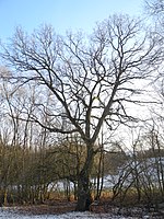
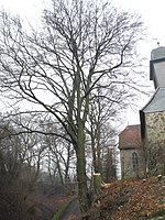
The list of natural monuments in Fuldatal called on the Municipality Fuldatal in the district of Kassel, in Hesse located natural monuments . These are currently trees at 6 locations and the extensive natural monument “Wetland Die Bruchwiesen im Rohrbach”.
Trees
| image | designation | District, location | description | Art | No. |
|---|---|---|---|---|---|
 more pictures |
1 oak |
Rothwesten 51 ° 22 ′ 59.4 ″ N , 9 ° 32 ′ 50.4 ″ E |
Pedunculate oak approx. 600 m east of the outskirts of Rothwesten. The tree stands on a dirt road northeast of Gut Eichenberg, "Am Bodenweg". The Eichenallee natural monument is only about 300 m further east (see below). Trunk circumference: 3.40 m Height: 19 m Planting year: approx. 1905 OSM link to map display: Oak near Rothwesten, Gut Eichenberg |
Quercus robur | 6.33.242 |
 more pictures |
1 oak |
Rothwesten 51 ° 23 ′ 35 ″ N , 9 ° 31 ′ 8.6 ″ E |
Pedunculate oak approx. 500 m north of the outskirts of Rothwesten. The tree is on Winterbürener Straße, the access road to Gut Winterbüren. The main trunk is sawn off at a height of about 6 m. Trunk circumference: 4.30 m Height: 23 m Planting year: approx. 1825 OSM -Link to map display: Oak near Rothwesten, Gut Winterbüren |
Quercus robur | 6.33.243 |
 more pictures |
1 linden tree |
Simmershausen 51 ° 22 '15.2 " N , 9 ° 31' 9.4" E |
Winter linden tree on the northern outskirts of Simmerhausen. The location of the tree is the war memorial on Karlstrasse. The lower branches of the linden tree grow almost horizontally, but they were secured by attached ropes from the main trunk. Trunk circumference: 3.55 m Height: 16 m Planting year: approx. 1875 OSM link to the map display: Linden tree in Simmershausen |
Tilia cordata | 6.33.244 |
 more pictures |
1 oak |
Simmershausen 51 ° 21 ′ 45.3 " N , 9 ° 30 ′ 31.6" E |
Pedunculate oak approx. 600 m southeast of the outskirts of Simmershausen. The tree stands on the edge of a strip of forest, in the area "Die Rohrbachswiesen". Trunk circumference: 4.05 m Height: 20 m Planting year: approx. 1885 OSM link to the map display: Oak near Simmershausen |
Quercus robur | 6.33.245 |
 more pictures |
1 beech |
Wahnhausen 51 ° 21 '53 " N , 9 ° 34' 4.4" E |
European beech on the eastern outskirts of Wahnhausen. The tree is on a steep slope just north of the church. In the crown of the beech, safety measures were carried out using ropes. Trunk circumference: 3.60 m Height: 26 m Year of planting: approx. 1855 OSM -Link to the map display: Beech at the church of Wahnhausen |
Fagus sylvatica | 6.33.246 |
 more pictures |
Oak alley |
Rothwesten 51 ° 22 '57.9 " N , 9 ° 33' 2.6" E |
Pedunculate oak approx. 1 km east of the outskirts of Rothwesten, east of Gut Eichenberg. The approximately 200 m long avenue of 53 trees rises slightly from east to west. The Kasselsteig hiking trail runs between the two impressive rows of trees. Trunk circumference: 1.50 - 2.80 m Height: 20 m Planting year: approx. 1905–1925 OSM link to the map display: The westernmost tree on the oak avenue near Rothwesten |
Quercus robur | 6.33.247 |
Extensive natural monuments
| image | designation | District, location | description | No. |
|---|---|---|---|---|
 more pictures |
Wetland The Bruchwiesen in the Rohrbach |
Ihringshausen and Simmershausen 51 ° 21 '41.7 " N , 9 ° 30' 54.1" E |
Wet fallow land with Großseggenried , trees, ponds and gallery forest south of Simmerhausen.
The Rohrbach flows through the natural monument, and there are also swamp areas. The water is colored rusty brown in places and there are colorful streaks on its surface. This is due to iron components in the water and the activity of iron bacteria . Area: approx. 3.0 ha OSM -Link to the map display: "Wetland The Bruchwiesen im Rohrbach" |
6.33.241 |
Web links
Commons : Natural monuments in Fuldatal - Collection of images, videos and audio files
supporting documents
- ↑ According to the official cadastre of the Lower Nature Conservation Authority of the district of Kassel and on-site research 2016/2017.
- ↑ a b c d e f information on trunk circumference, size and planting year according to Rüdiger Germeroth, Horst Koenies, Reiner Kunz: Natural cultural assets - past and future of natural monuments in the district of Kassel , publisher: District Committee of the District of Kassel, Lower Nature Conservation Authority, Wolfhagen, 2005, Appendix "Trees" p. 186 ff. The year of planting was calculated back using the age estimated there and the year of publication (2005) of the publication.
- ↑ Information according to Rüdiger Germeroth, Horst Koenies, Reiner Kunz: Natural cultural assets - past and future of natural monuments in the district of Kassel , publisher: District Committee of the district of Kassel, Lower Nature Conservation Authority, Wolfhagen, 2005, appendix " Large-scale natural monuments" p. 162 ff.


