List of natural monuments in Zierenberg
The list of natural monuments in Zierenberg called the in the field of city Zierenberg in Kassel district in Hesse located natural monuments . These are currently trees at 8 locations, as well as 9 area natural monuments. This means that Zierenberg has the largest number of extensive natural monuments in the Kassel district. The most famous of these is likely to be the “Helfenstein” on the Hohen Dörnberg .
Trees
| image | designation | District, location | description | Art | No. |
|---|---|---|---|---|---|
 more pictures |
1 linden tree |
Oberelsungen , Zur Trift 51 ° 22 ′ 43 ″ N , 9 ° 14 ′ 1.6 ″ E |
Winter linden tree on the northern outskirts of Oberelsungen. The tree stands on a green area "Im Wargrund", on the street "Zur Trift". Trunk circumference: 4.05 m (2005: 3.75 m) Height: 15 m Planting year: approx. 1855 OSM -Link to the map display: Winter linden tree in Oberelsungen |
Tilia cordata | 6.33.902 |
 more pictures |
2 linden trees |
Oelshausen 51 ° 18 '56.2 " N , 9 ° 15' 30.5" E |
Winter linden trees on the north-western outskirts of Oelshausen. The two trees flank the main entrance to the cemetery. The northern tree: trunk circumference: 3.60 m (2005: 3.40 m) height: 20 m year of planting: approx. 1925 OSM link to the map display: northern winter linden tree in Oelshausen The southern tree: trunk circumference: 2.70 m (2005: 2.40 m) Height: 17 m Year of planting: approx. 1925 OSM link to the map display: southern winter linden tree in Oelshausen |
Tilia cordata | 6.33.906 |
 more pictures |
1 linden tree |
Zierenberg 51 ° 22 ′ 18.7 ″ N , 9 ° 19 ′ 27.5 ″ E |
Summer linden tree approx. 2 km northeast of the town center of Zierenberg. The tree stands by the railway tunnel on the Kassel - Wolfhagen railway line. The Habichtswaldsteig hiking trail leads directly past the linden tree . Trunk circumference: 4.30 m Height: 27 m Planting year: approx. 1855 OSM -Link to the map display: Summer linden tree at the railway tunnel |
Tilia platyphyllos | 6.33.908 |
 more pictures |
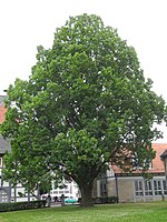
1 pyramidal oak |
Zierenberg 51 ° 22 ′ 6.6 ″ N , 9 ° 18 ′ 3.7 ″ E |
Pyramid oak in the center of Zierenberg. The tree stands on the lawn of the church yard of the town church, directly next to the building, north of the choir. Trunk circumference: 3.45 m (2005: 2.90 m) Height: 15 m Planting year: approx. 1915–1925 OSM link to the map display: Pyramid oak at the city church |
Quercus robur 'Fastigiata' | 6.33.909 |
 more pictures |
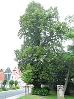
1 linden tree |
Zierenberg 51 ° 21 ′ 59.9 ″ N , 9 ° 17 ′ 57 ″ E |
Summer linden tree on the southwestern edge of the old town of Zierenberg. The tree stands on the edge of the old cemetery, directly on Oberelsunger Straße. Trunk circumference: 4.40 m Height: 24 m Planting year: approx. 1805 OSM -Link to the map display: Summer linden tree at the old cemetery |
Tilia platyphyllos | 6.33.911 |
 more pictures |
1 linden tree |
Zierenberg 51 ° 22 ′ 3.3 ″ N , 9 ° 17 ′ 0 ″ E |
Winter linden tree approx. 500 m west of the city limits of Zierenberg. The tree is located next to an asphalt farm road between Oberelsunger Straße and the A 44 . The motorway is only approx. 200 m away, and its background noise dominates the landscape. Trunk circumference: 2.90 m Height: 18 m Planting year: approx. 1915 OSM link to the map display: Winter linden tree on the motorway |
Tilia cordata | 6.33.915 |
 more pictures |
Grove of trees "Freistuhl" |
Zierenberg 51 ° 23 ′ 30.4 " N , 9 ° 18 ′ 40" E |
Pedunculate oak with surrounding tree circle approx. 3 km north of the town center of Zierenberg. The location is remote in the forest, about 250 m northeast of the Schartenberg castle ruins . The natural monument consists of a central oak, which is surrounded by a tree circle made up of 4 other oaks, 6 red beeches and 1 hornbeam. Two of the beech trees, however, only consist of the dead trunk (so-called standing dead wood ). The Fulda-Diemel-Weg hiking trail leads west around the natural monument on a forest path ; a small branch is necessary to reach the group of trees. Trunk circumference: up to 3.35 m in height: up to 18 m year of planting: approx. 1805 OSM link to the map display: central oak in the tree circle "free chair" |
Quercus robur + Fagus sylvatica + Carpinus betulus |
6.33.919 |
 more pictures |
1 oak "Rohrbach oak" |
Zierenberg 51 ° 20 ′ 57.8 " N , 9 ° 17 ′ 29.8" E |
Pedunculate oak on a green area between fields, about 1 km south of the Zierenberg city limits. The tree stands next to a farm road, approx. 750 m east of the A 44 . In March 2007 the "Rohrbach oak" was added as a natural monument to compensate for the loss of a copper beech in Oberweser. Trunk circumference: 4.60 m Height: 22 m Planting year: approx. 1855 OSM -Link to the map display: "Rohrbach oak " south of Zierenberg |
Quercus robur | 6.33.921 |
Extensive natural monuments
| image | designation | District, location | description | No. |
|---|---|---|---|---|
 more pictures |
Holy grove |
Burghasungen 51 ° 19 ′ 1.8 ″ N , 9 ° 17 ′ 8.6 ″ E |
Basalt rocks with beech trees approx. 1 km southeast of Burghasungen. The natural monument consists of individual, cliff-like, approximately 1–3 m high basalt rocks between which beech trees grow. Directly below the slope crowned with the basalt rocks, in the northeast, runs the highway 44 with its noise emissions. Area: approx. 0.62 ha OSM -Link to the map display: "Heiliger Hain" near Burghasungen |
6.33.901 |
 more pictures |
Pipe head |
Oberelsungen 51 ° 22 ′ 32.4 " N , 9 ° 15 ′ 26.7" E |
Partly wooded limestone dome with poor grass approx. 1 km east of Oberelsungen. The summit has been designated as an extensive natural monument since 1990. From 1992, the NABU Oberelsungen created a meadow orchard and hedges on the neighboring areas. In 2009 NABU acquired the natural monument and is developing a protected area on a total of 2.4 hectares. Area: approx. 0.6 ha OSM link to the map display: "Rohrköppel" near Oberelsungen |
6.33.904 |
 more pictures |
Flax roast |
Oberelsungen 51 ° 22 ′ 38.4 " N , 9 ° 12 ′ 51.5" E |
Wet fallow land with ponds approx. 1 km west of Oberelsungen. The natural monument is located in the middle of cleared agricultural areas. The ponds in the west were artificially created in the 1970s and are surrounded by reed belts. The area is looked after by NABU Oberelsungen. The field name "Flax roasting" indicates an old location for flax fiber processing, cf. " Flax rot ". Area: approx. 1.0 ha OSM link to the map display: " Flachsröste " near Oberelsungen |
6.33.905 |
 more pictures |
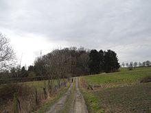
Chat stones |
Zierenberg 51 ° 21 '33.3 " N , 9 ° 17' 4.3" E |
Basalt dome with oaks and hornbeams on the southwestern outskirts of Zierenberg. The natural monument is located next to Autobahn 44 and its background noise. A path leads from the west side of the hill to the summit, where the basalt comes to the surface. The part of the name Chatten (also written Katten ) refers to a Germanic tribe, whose settlement area also includes today's Zierenberg. In Zierenberg, not far from the natural monument, there is also the street name Zum Kattenstein . Area: approx. 0.64 ha OSM link to the map display: "Chattensteine" near Zierenberg |
6.33.910 |
 more pictures |
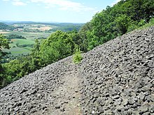
The blue stones |
Zierenberg 51 ° 22 ′ 34.7 " N , 9 ° 18 ′ 26" E |
Large basalt rubble field north of Zierenberg. The area is located on the steep southwest slope of the Großer Schreckenberg . The scree field is largely free of vegetation, with only a few linden trees. The Habichtswaldsteig hiking trail leads through the terrain in a few hairpin bends . Area: approx. 2.0 ha OSM link to the map display: "The Blue Stones" near Zierenberg |
6.33.912 |
 more pictures |
Basalt summit The control room |
Zierenberg 51 ° 22 ′ 37.7 " N , 9 ° 17 ′ 19.4" E |
Basalt -Kuppe with dry grasslands, semi-dry grasslands and trees about 1 km northwest of Zierenberg. In the north-west of the knoll there is an abandoned basalt quarry overgrown by trees. A path leads to the highest point. There is the Zierenberger Warte , a round, stone watchtower from the Middle Ages, from which the site got its name. Area: approx. 3.0 ha OSM -Link to the map display: “Basaltkuppe Die Warte” near Zierenberg |
6.33.916 |
 more pictures |
Hundsberg |
Oelshausen 51 ° 18 '30 " N , 9 ° 16" 58.6 " E |
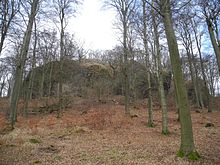
Basalt rocks with basalt stone heaps east of Oelshausen. The summit is in a deciduous forest and is not accessible by paths. The natural monument status has existed since 2005. Area: approx. 2.0 ha OSM -Link to the map display: "Hundsberg" near Oelshausen |
6.33.917 |
 more pictures |
Helfenstein |
Zierenberg 51 ° 21 '43.4 " N , 9 ° 20' 50.9" E |
Striking basalt rocks with basalt block halden on High Dörnberg , approximately 3.0 km east from Zierenberg. Several rocks of different sizes protrude from a woodless knoll from which there is a wide view. Hiking trails, including the Habichtswaldsteig and the Kassel-Steig, lead across the open terrain . It was placed under protection as a natural monument in 2005. Area: approx. 4.5 ha OSM -Link to the map display: "Helfenstein" on Dörnberg |
6.33.918 |
 more pictures |
Kassel sea sand |
Zierenberg 51 ° 21 '59.7 " N , 9 ° 16' 3.6" E |
Slipped section of the Kassel sea sand in the forest, approx. 2 km west of Zierenberg. It is a geotope from the Upper Oligocene period, also known as the Chattium . The natural monument consists of a superficially unspectacular slope piece along a forest path. The fine-grained quartz sand exposed on the slope edge contains marine fossils such as mussel shells. An information board on site describes the geological background. The natural monument status has existed since 2005. Area: approx. 0.22 ha OSM -Link to the map display: "Kasseler Meeressand" near Zierenberg |
6.33.920 |
Web links
Commons : Naturdenkmale in Zierenberg - Collection of pictures, videos and audio files
supporting documents
- ↑ Measurement 2017-03-03 in h = 1.30 m
- ↑ a b c d e f g Information on trunk circumference (if no own measurement), size and planting year according to Rüdiger Germeroth, Horst Koenies, Reiner Kunz: Natural cultural assets - past and future of natural monuments in the Kassel district , publisher: District Committee of the Kassel District, Lower Nature Conservation Authority, Wolfhagen, 2005, Appendix "Trees" p. 186 ff. The year of planting was calculated back using the age estimated there and the year of publication (2005) of the publication.
- ↑ Measurement 2017-02-25 in h = 1.30 m
- ↑ Measurement 2017-02-25 in h = 1.30 m
- ↑ measurement in 2017-06-24 h = 1.30 m
- ↑ measurement in 2017-06-24 h = 1.30 m
- ^ Zierenberg. In: List of the individual objects (trees and groups of trees), status 07.09.2007 ; Yumpu.com, online pdf document. (No longer available online.) Archived from the original on June 26, 2016 ; accessed on June 24, 2016 . Info: The archive link was inserted automatically and has not yet been checked. Please check the original and archive link according to the instructions and then remove this notice.
- ↑ a b c d e f g h i j Information from Rüdiger Germeroth, Horst Koenies, Reiner Kunz: Natural cultural assets - past and future of natural monuments in the Kassel district , publisher: District Committee of the Kassel District, Lower Nature Conservation Authority, Wolfhagen, 2005, Appendix " Extensive natural monuments "p. 162 ff.
- ↑ Paragraph to: www.nabu-oberelsungen.de The NABU protected area "Rohrköppel Oberelsungen" , accessed on March 8, 2017

