
Korafi range of hills
The Korafi range of hills ( Albanian Kodrat Korafi , also Kodrat e Stilit ) is a range of hills in the extreme south of Albania or in the north-west of Greece . The western part is also called the Stillo Peninsula .
geography

The range of hills is over 15 kilometers long and runs in a south-southeast-north-northwest direction between the alluvial plain of the River Pavlla (Fusha e Xarrës) in the north and the Ionian Sea in the south. The Korafi-hilly terrain begins at Qafa Boti ( 140 m above sea A.. In) Konispol where he into epirische merges mountains, and ends at the Cape Stillo that - not ten kilometers from Corfu removed the southeastern entrance to the Strait of Corfu forms . The first village in Greece a little southeast of the hill range is Sagiada . To the north of the western end of the range of hills is the archaeological site of Butrint .
The limestone range of hills in the north, where it drops quite steeply, has a fairly straight course, only interrupted by a few torrents . The coast in the south, on the other hand, is more indented and less steep. In addition to bays leading deep into the interior, the two Albanian islands of Tongo and Stillo can be found here . In the west the range of hills rises to 269 m above sea level. A. at. Between Mursia and the Bay of Kato Aetos the ridge falls sharply to 41 m above sea level. A. from, but then rises to 414 m above sea level. A. high Mali i Olivës . The incision is, apart from one incision west of Qafa Boti, the only point where the ridge is below 100 m above sea level. A. falls.
In the eastern area the character of the hill range changes. Here it drops more steeply to the south and is more unclearly structured in the northern area. A pyramid-shaped hill, the Çuka e Aitoit ( 273 m above sea level ), an ancient settlement, is in front of Çiflik.
The coastal section in the south of the range of hills, apart from around three kilometers in the west to the bay of Gjiri i Fteliasit, belongs to Greece. The border rises from there to the east to the ridge and then follows this east to just before the Qafa Boti, where it deviates slightly to the south. A strip of land several kilometers long, usually not a kilometer wide, is formed in the far north-west of Greece.
Nature, use and history
The western Albanian part has belonged to the Butrint National Park since 2005 and is part of a Ramsar reserve .
Due to its proximity to Greece, the area was a military zone until 1992 and access was prohibited.
As a former border area on the Albanian side, the Korafi range of hills has hardly been developed and is actually only visited by shepherds . There is a lot of oak forest - especially important holm oak - and maquis in the valleys. The west around Cape Stillo is home to many birds that appreciate rocky terrain, including white-tailed eagles , peregrine falcons , stone fowl , blue umler , rock nuthatch and wheatear . The west is wild and uninhabited and is home to wild boars , wolves and jackals . Sea turtles are supposed to lay eggs on the small sandy beaches, while wide-brimmed tortoises and Greek tortoises are on the way on land .
There are various fish farms along the south coast . The Greek section is accessed by a road. High voltage lines run along the Greek kisses, which then lead underwater to Corfu.
At Cape Stillo there are prehistoric fortifications, which are believed to date from the Bronze Age . An incomplete rectangular enclosure wall rests on a prominent hill. It surrounds an area of 1.5 hectares that may have been partially terraced . The simple limestone building, originally up to 2.3 meters high, has been partially preserved at a height of 0.8 to 1.5 meters and probably included an entrance gate. The location offered a good overview of Butrint and almost the entire east side of the island of Corfu, which allowed a control of the shipping traffic in the area of Corfu and Butrint. There are no building remains, but ceramics from the Bronze Age, Iron Age , Antiquity and the Middle Ages have been found.

Eastern part of the mountain range and mountains around Konispol seen from the north (Butrint)

Central part of the range of hills seen from the north (Butrint)
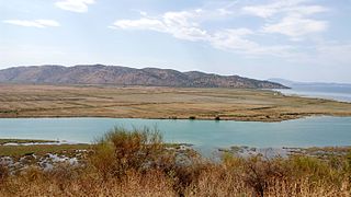
Western part of the range of hills seen from the north (Butrint)


literature
- Ilir Gjipali, S. Lima: The settlement at Stilo . In: Ilir Gjipali, Luan Përzhita, Belisa Muka, Center for Albanian Studies / Institute of Archeology (Eds.): Recent archaeological discoveries in Albania . Albanologjike, Tirana 2013, ISBN 978-9928-14116-3 , pp. 40-43 .
Individual evidence
- ↑ Akademia e Shkencave e RPSSH (ed.): Gjeografia fizike e Shqipërisë . tape 2 . Tirana 1990, p. 392 .
- ↑ a b c military map 1: 50,000, pages J-34-4-D (2nd edition, Tirana 1982), J-34-5-C (2nd edition, Tirana 1983), J-34-17-A ( 2nd edition, Tirana 1982)
- ↑ a b Akademia e Shkencave e RPSSH (ed.): Gjeografia fizike e Shqipërisë . tape 2 . Tirana 1990, p. 385 .
- ↑ Ministria e Kulturës (ed.): Parku Kombëtar i Butrintit: Plani i Menaxhimit të Integruar (2020-2030) . Tirana April 2020, p. 166 ( kultura.gov.al [PDF; accessed July 12, 2020]).
- ^ A b c Daniel Renton, Tao Bino, Sally Martin, Gary Wimberley: Butrint National Park. A Guide to the Environment and Walking Trails . Ed .: The Butrint Foundation, Butrint National Park. Saranda 2005, Korafi Hills, p. 17 .
- ↑ Akademia e Shkencave e RPSSH (ed.): Gjeografia fizike e Shqipërisë . tape 1 . Tirana 1990, p. 330 f .
- ↑ a b Butrint.org: Korafi Hills and Cape Stillo ( Memento from July 29, 2014 in the Internet Archive )
- ↑ Google Maps. Retrieved July 12, 2020 (as an example for many more).
- ↑ Google Maps. Retrieved July 12, 2020 .
- ↑ Grid Map. In: IPTO. Retrieved July 12, 2020 .
- ^ Inge Lyse Hansen, Richard Hodges, Sarah Leppard: Butrint 4: the archeology and histories of an Ionian town . Oxbow Books, Oxford 2013, ISBN 978-1-78297-102-3 , Cape Stillo, pp. 35 ( limited preview in Google Book search).
- ^ Andreas Lippert : Stillo . In: Christian Zindel, Andreas Lippert, Bashkim Lahi, Machiel Kiel (eds.): Albania: an archeology and art guide from the Stone Age to the 19th century . Böhlau, Vienna 2018, ISBN 978-3-205-20723-8 , pp. 187 f .
Coordinates: 39 ° 42 ' N , 20 ° 0' E