Butrint National Park
| Parku Kombëtar Butrinti | ||
|---|---|---|
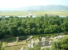
| Butrint theater and wetlands south of the Vivar Canal | ||
|
|
||
| Location: | Vlora Qark , Albania | |
| Specialty: | Archaeological sites, lake, wetlands | |
| Next city: | Saranda | |
| Surface: | 9,424.4 ha | |
| Founding: | 2000 (extended 2005) | |
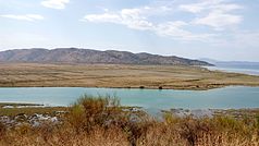
| Plains and wetlands beyond the canal | ||
The Butrint National Park ( Albanian Parku Kombëtar Butrinti ) is a national park in southern Albania about 25 kilometers south of Saranda . The 9,424.4 hectare site includes the coastal area on the Ionian Sea in southern Albania with Lake Butrint , the small adjacent Bufi Lake , the Ksamil peninsula , the Vrina plain, the wetlands on the Vivar Canal and the mouth of the Pavlla and the hills on Cape Stillo .
The center of the park and its main attraction is the ancient site of Butrint , which is a UNESCO World Heritage Site and attracts numerous tourists. Other remains from ancient times - Roman villas and temples and the Kalivo complex from the Bronze Age - as well as Venetian and Ottoman fortresses such as the fortress of Ali Pasha are also part of the national park. The area with its many bodies of water and wetlands is above all an important refuge for wild animals. The bay of Gjiri i Fteliasit and the island of Tongo are located on the pristine southern coast around Cape Stillo and the Greek border .
The protected area around Butrint has undergone several extensions over time - the most important are:
- 1948: Butrint is declared a cultural monument.
- 1992: The area of the ancient city of Butrint (16 hectares) becomes a World Heritage Site by UNESCO.
- 1999: The world heritage protection zone is expanded to 2500 hectares; it encompasses the entire southern end of the peninsula, the southern part of the Butrintsee, the Bufi Lake, the Vivar Canal, the wetlands between the mouths of the Canal and Pavlla and the northern part of the Vrina plain south of the Canal.
- 2000: The area is declared a national park.
- 2003: The Butrintsee and the surrounding wetlands have been Ramsar protected areas since 2003 ; the core zones of the 13,500 hectare area lie within the national park.
- 2005: The national park is expanded from 2500 to 8591.2 hectares, of which 3980 hectares are the core zone; The park encompasses the whole Butrintsee, the whole peninsula including the place Ksamil, the south of the Vurgu plain north of the lake, the mountain Mali i Milës ( 695 m above sea level ) east of the lake, the intermediate Bufi lake, the Vrina plain to the villages of Xarra and Vrina and the whole coast around Cape Stillo to the Greek coast.
- 2013: The national park is expanded to an area of 9424 hectares, the core zone is reduced to 3958.29 hectares; the park now also includes a stretch of sea along the coast of 1.5 kilometers, including the Ksamil Islands .
The wetlands are home to 14 endangered animal species, and nowhere else in Albania have so many bird (246), reptile (25) and amphibian (10) species been found. In addition, 105 species of fish and 39 species of mammals were detected. Only in these areas are the Epirus water frog ( Rana epeirotica ), the wide-brimmed turtle ( Testudo marginata ), the western sand boa ( Eryx jaculus ) and the Taurian lizard ( Podarcis taurica jonica ) at home. Lake and the surrounding area are also an important resting place for migratory birds such as grebes , little grebes , Common Goldeneye , Coot and Pochard . Rare sea creatures such as the endangered loggerhead turtle and perhaps the endangered Mediterranean monk seal as well as birds of prey such as hen harriers , marsh harriers and sea eagles can be found in and around the lake.
Web links
- Management plan 2020–2030 (PDF, Albanian)
literature
- Richard Hodges : Creare il Parco Nazionale di Butrinto in Albania . In: Archeologia Medievale . tape XXXVI , 2009, ISSN 0390-0592 , p. 7–19 ( insegnadelgiglio.it [PDF; accessed November 20, 2018]).
Individual evidence
- ↑ Rrjeti i zonave të në mrojtura Shqipëri. (PDF) (No longer available online.) In: Ministria e Mjedisit. March 2014, archived from the original on September 5, 2017 ; Retrieved January 15, 2015 (Albanian).
- ↑ a b Ministria e Kulturës (ed.): Parku Kombëtar i Butrintit: Plani i Menaxhimit të Integruar (2020-2030) . Tirana April 2020, p. 157–177 ( keshillikonsultativ.qeverisjavendore.gov.al [PDF; accessed July 7, 2020]).
- ↑ a b Butrint National Park Walking Trails Leaflet. (No longer available online.) In: Slideshare. Butrint National Park / Butrint Foundation, archived from the original on February 2, 2016 ; accessed on February 2, 2016 .
- ^ Information Sheet on Ramsar Wetlands - Butrint. (PDF; 220 kB) In: ramsar.org. March 20, 2003, accessed January 12, 2016 .
- ^ Butrint Foundation, Butrint National Park (Ed.): Butrint National Park - A guide to the Environment and Walking Trails


