Pavlla
|
Pavlla Pavllë, Pavla, Παύλα |
||
|
muzzle |
||
| Data | ||
| location | Albania , Greece | |
| River system | Pavlla | |
| source | Mourgana Mountains, Greece | |
| muzzle |
Ionian Sea Coordinates: 39 ° 43 ′ 37 " N , 19 ° 59 ′ 39" E 39 ° 43 ′ 37 " N , 19 ° 59 ′ 39" E |
|
| Mouth height |
0 m above sea level A.
|
|
| length | approx. 50 km | |
| Discharge at the estuary A Eo : 374 km² at the estuary |
MQ Mq |
7.2 m³ / s 19.3 l / (s km²) |
| Communities | Konispol | |
|
Lower course |
||
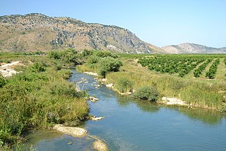
The Pavlla ( Albanian Pavla, Pavllë ; Greek Παύλα Pavla ) is a small river about 50 kilometers long in the extreme south of Albania . Its source is in the mountains of northern Greece . Besides the Bistrica , the Pavlla is the only river in the country worth mentioning that does not flow into the Adriatic Sea , but into the Ionian Sea .
The Pavlla is around 50 kilometers long and drains the southernmost tip of Albania, as well as some small areas in Greece. Its catchment area covers 374 square kilometers.
A stream south of the mountain Maja e Shtugarës ( 1759 m above sea level ) on the Albanian-Greek border is given as the source . It belongs to the Mourgana mountain range, which has its highest point seven kilometers south-east in the Maja e Murganës ( 1806 m above sea level ). The area northwest of the Maja e Shtugarës around Leshnica also belongs to the catchment area of the Pavlla.
The upper course in Greece is also called Ksantos. South of the village of Tsamantas (Τσαμαντάς), which belongs to the municipality of Filiates , the main source streams come together. From here the river runs to the west, in deep gorges running through several mountain ranges that separate it from the sea coast. After a little more than five kilometers, soon after the first gorge, the limit is reached. The next puncture takes place a few kilometers later. Then the valley widens and the Pavlla takes in larger tributaries from the north and south. At the village of Shalës the Pavlla turns to the southwest and pierces another mountain range. Then it runs from the village of Çiflik (northwest of Konispol ) to the northwest. On the southern edge of the Vrina plain, the river follows the Korafi range of hills for around twelve kilometers, before flowing into the Strait of Corfu between Cape Stilo (Kep i Stilos) and the Vivar Canal , the outflow of the Butrintsee .
The area around the estuary is part of the Butrint National Park .
The catchment area of the Pavlla is not densely populated. Much of it is mountainous. The plains on the lower reaches are used for agriculture, the water of the river is used for irrigation. At Çiflik, water is diverted and fed into a small reservoir near the village of Mursia.
Individual evidence
- ↑ a b c d Niko Pano: Pasuritë ujore të Shqipërisë . Akademia e Shkencave e Shqipërisë , Tirana 2008, ISBN 978-99956-10-23-4 , Pavla, p. 265 .

