
Border between Albania and Greece

The border between Albania and Greece separates the territory of the Republic of Albania from the Hellenic Republic (Greece) . It has a length of around 300 kilometers on approximately 180 kilometers as the crow flies.
Borderline
The common state border runs in a north-westerly direction from the Ionian Sea between the southern mountains of Albania ( Krahina malore jugore ) and the Greek region of Epirus (Ipiros) over the Pindus Mountains to Western Macedonia (Dytikí Makedonía) , where the tri-border region with North Macedonia lies in Lake Prespa . The mountain ridges in front of the Pindos graze here parallel to the coast northwest to southeast, so that the border initially crosses several ridges and some valleys. In the further course it is in parts a high mountain border and watershed , later it runs across lakes.
Both states claim territorial waters of twelve nautical miles .
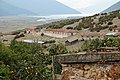
The border begins at Ftelias Bay (Gjiri i Fteliasit) east of Cape Stilo (Kep i Stilos) , opposite the Bay of Kerkyra (Corfu) , south of Butrint and northwest of Asprokklisi . It then leads a good 15 kilometers - between a narrow Greek coastal strip and the Albanian coastal plain on the lower reaches of the Pavlla - southeast over the Korafi range of hills , which runs from the Stilo hill ( 269 m above sea level ) to the border mountain Ovila ( 414 m above sea level ) . ) is running at Çiflik . Then it crosses the Aspropotamos River near Konispol , Albania's southernmost town . There is also the border crossing Qafa Boti- Sagiada , the westernmost border crossing the land border. It continues over the mountain Mali i Nartës ( 854 m above sea level ) inland.

Approximate course of the border in the Strait of Corfu
|

|

As a result, the border changes direction to the northeast. It crosses several valleys, including that of the Pavlla, and the southern foothills of the Mali i Gjerë on the Maja e Murganës (approx. 1806 m above sea level ), and reaches the Drino valley with the border crossing Kakavija- Ktismata . Then it crosses the Buretoja train to the Pogoni area southeast of Libohova . It then leads over the Nemërçka mountain range over the Tumba (approx. 1543 m ) into the Vjosa / Aoos valley , where the Tre Urat – Konitsa border crossing is located. Then it stretches north into the Mali i Gramozit / Grammos mountain range with the Maja e Çukapeçit / Grammos ( 2520 m ) as the main and border summit and descends along the main ridge towards the Ohrid / Prespa lakes.
On the southern edge of the Devoll Basin , the border south of Bilisht cuts through a loop of the Kore , a tributary of the Aliakmonas , and thus forms Albania's only area that is drained to the Aegean Sea . There is another border crossing between Kapshtica and Kastoria , which is located at an altitude of over 1000 m . Over the Mali i Karvanit ( 1548 m above sea level ) it goes to the Small Prespa Lake , whose silting western end it crosses. Across further mountains with the Mali i Vervos ( 1416 m above sea level ) it reaches the Great Prespa Lake , in the middle of which, not far from the island of Golem Grad, lies the triangle with the Macedonian border , called the Triethnes (three peoples) .
Albania and Greece also have a sea border in the Strait of Corfu : It leads around Cape Stilo northwards through the Strait of Corfu, where at the narrowest point only about two kilometers separates the island of Corfu at its northern end from the Albanian mainland at Ksamil . The course is still unclear.
At both ends of the land border there are two protected areas, national parks and significant wetlands: on the Albanian side, the Parku Kombëtar i Butrint around Lake Butrint, and the cross-border Prespa Park on Lake Prespa ( Parku Kombëtar i Prespës and Ethnikos Drymos Prespon ). Several Greek protected areas, including the Ethnikos Drymos Vikou-Aoou , are only a short distance from the border.

Korafi range of hills south of Butrint

Grammos , south side
Small Prespa lake , view from Albania across the border


| Territorial waters of the Ionian Sea | (u) |
|
Albanian-Greek border |
|
Albanian-North Macedonian border |
| greek-north macedonian border | |||||
| Strait of Corfu | Gjiri i Fteliasit | Prespa lake (Triethnes) | |||
- (u) unexplained
history

.jpg)
The border crosses the ancient landscapes of Epirus and Chaonia . In antiquity they belonged to Rome , then to Eastern Europe , since the end of the Middle Ages they were the core area of the Ottoman Empire in the European region of Rumelia (the name was formed from "Rome").
When Greece became independent in 1821 , Epirus and Macedonia remained with the Ottoman Empire, the Paschaliks ( Eyâlets , then Vilâyets ) Yanya / Janina (Ioannina) and Manastır / Monastir (in Bitola). The border ran at Arachthos (Arta). In 1881 Tırhala / Trikala also came to Greece. It was not until the Balkan Wars of 1912/13 that the Greeks were able to join most of Epirus to their state, while the north with Saranda, Delvina , Gjirokastra and Korça fell to Albania. This area is called Northern Epirus in Greek .
The limit was set at the London Ambassadors' Conference on the reorganization of the Balkans after the collapse of the Ottoman Empire , the "sick man on the Bosporus" and fixed in the Treaties of London of May 30, 1913 and of Florence of December 17, 1913. In northern Epirus , however, an autonomous (northern) Epirus was proclaimed in 1914 , first as a republic, then as an Albanian territory, which was occupied by Greece in the same year and formally annexed in 1915. It was only after the First World War that the borders were consolidated in the state of the pre-war treaty and were confirmed in the course of the Treaty of Rapallo in 1920.
On October 28, 1940, Italy attacked Greece from occupied Albania. In the course of the Greco-Italian War , the Greek troops, after initial successes from Italy, managed to move the front far beyond the border to the north. The state of war between Greece and Albania was not formally ended until 1987. Mines in the Strait of Corfu led to the international Corfu Canal Incident in 1946 . The border was closed for a long time after the Second World War; There was practically no border traffic.
The Grammos was a bastion of the communist-oriented rebels in the Greek civil war from 1946 to 1949, who were supported by Albania (until 1948 also by Tito's Yugoslavia and Stalin's Soviet Union ). The minefields of this time have not yet been completely removed despite extensive clearance measures.
In 1981 Greece became a member of the EEC (later the EU), in 1992 it also ratified the Schengen Agreement on free border traffic, in which it is still an exclave today, Albania only began accession negotiations in 2014 . After decades of tension between Greece and Albania, even after the collapse of communism in 1990 , a rapprochement policy began in the mid-1990s. In 1995, the question of the proportion of the Greek population in northern Epirus was resolved: Tirana recognized the ethnic group with minority status.
The border is as affected by smuggling as it is by labor migration . As early as the 1990s, 300,000 Albanian foreign workers were mostly illegally staying in Greece. Between 2008 and 2010, for example, around 35,000–40,000 illegal border crossings were on record every year. When the visa requirement for Albanians was lifted in 2010 , the number dropped to around 5,000 and had stabilized at around 9,000 annually by 2015. Labor migration affects cross-border commuters from neighboring regions of Greece as well as all of Albania: Migrants in the second group tend to commute seasonally or try to emigrate entirely; plays locally with respect to the often ill-informed non-locals smuggling as well as fraud, such as currency exchange, a role. Because they stay longer in the area while waiting for people to be smuggled or after being pushed back, they are perceived locally as a nuisance or even a threat.
The maritime border is still the subject of disputes. Greece has declared a 6-mile zone . The course of the bilateral maritime border was negotiated in an agreement in 2009. However, this was challenged by the - then opposition - socialists under Rama and declared invalid by the Albanian constitutional court in 2010. With Albania's recent plans for mineral exploration, tensions have returned between Tirana and Athens.
- chronology
- (indented for modern times, times of war and clarifications; in brackets: respective sub-areas)
- until 1821: no border (Inner Ottoman, Eyâlet Rumelia )
- 1800–1820 (de facto): Albanian rule by Ali Pasha
- 1821–1912 border Ottoman Empire ( Rumelia, Eyt. , Then Yanya, Eyt. / From 1867 Yanya, Vyt. And from 1874 Manastır, Vyt. ) - Greece, Kgr.
- since 1912: Albania border , 1913 (de jure) Fst. , 1920 Republic , 1928 Kgr. , 1944 Soc.VR. , 1990 Republic - Greece , Kgr. , 1924 Rep. , 1934 Kgr. , 1967 military dictatorship , 1973 Republic
- 1913; set today's limit
- 1914–1918: no border: Northern Epirus, Autonomous Rep. ; occupied by Greece and annexed in 1915
- 1940–1944: no border: Italian occupation, from 1941/43 German
Border crossing and border traffic
The border is an EU external border and also an external Schengen border (area of free border traffic).
The border has been a special place for irregular migration in and out of the European Union for many years and was run by the EU border protection authority Frontex as a separate migration route (Circular route from Albania to Greece) , but is now summarized under the Western Balkan Route in a larger context.
International border crossings between the two states are (the Albanian side mentioned first):
-
Qafa Boti (near Konispol ) - Sagiada (an Liqeni / Aspropotamos) on the route Saranda SH 97 - Igoumenitsa
 (opened in 2005)
 -
Kakavija - Ktismata (an Drino / Fitóki) on the route Tepelena - Gjirokastra - Ioannina -


-
Leskovik - Konitsa ( Tri Urat - Melissopetra ; an Vjosa / Aoos or Sarantaporos) on the route Tepelena - Përmet SH 80 or Leskovik
 - Konitsa 35α
-
Kapshtica - Krystallopigi on the route Korça - Bilisht - Florina resp. Kastoria


Ferries or speedboats run daily between Saranda and Kerkyra .
literature
- Gilles de Rapper, Pierre Sintès: Composer avec le risque: la frontière sud de l'Albanie entre politique des États et solidarités locales. In: Revue d'études comparatives Est-Ouest , n ° 4, Vol. 37, 2006, pp. 243-271.
Individual evidence
- ^ Albanian Government Confirms Greece's Right to Double Territorial Waters. In: Exit. August 26, 2020, accessed on August 31, 2020 .
- ↑ a b Georges Prevelakis: Géopolitique de la Grèce. Complexe, Paris 2006, ISBN 2-8048-0073-3 , p. 21.
- ↑ → fr: Traité de Florence (1913)
- ^ Klaus-Detlev Grothusen : Foreign Policy . In: Klaus-Detlev Grothusen (Hrsg.): Albanien (= Südosteuropa-Handbuch ). tape VII . Vandenhoeck & Ruprecht, Göttingen 1993, ISBN 3-525-36207-2 , pp. 142 .
- ↑ a b Greece and Albania bury the hatchet. In: Die Welt , online, March 23, 1996.
- ↑ See for example Karl Kaser, Robert Pichler, Stephanie Schwandner-Sievers (eds.): The wide world and the village: Albanian emigration at the end of the 20th century. Volume 3 of Zur Kunde Südosteuropas: Albanologische Studien , Böhlau Verlag, Vienna 2002, ISBN 978-3-205-99413-8 ( limited preview in Google book search).
- ↑ a b Western Balkan Route. (No longer available online.) In: Frontex. Archived from the original on March 29, 2016 ; accessed on April 14, 2019 (English). Info: The archive link was inserted automatically and has not yet been checked. Please check the original and archive link according to the instructions and then remove this notice.
- ↑ a b Frontex: Circular route from Albania to Greece ( Memento from March 29, 2016 in the Internet Archive )
-
↑ a b Gilles de Rapper: Crossing Borders: Migration in the Albanian border region Devoll. In [above]: Kaser, Pichler, Schwandner-Sievers: The wide world and the village. 2002, pp. 83-124;
The Albanians from the border region even have two different expressions for this, the local commuters are referred to as “ janë / punon Greki ” (“is / works in Greece”), those from regions remote from the border as “ refugiat ” (“refugee, exile”); de Rapper, p. 86 ff and Chapter Two Types of Migration , p. 88 ff ( limited preview in Google Book Search). - ↑ European Parliament, Directorate-General for Internal Policies of the Union; Juan Luis Suárez de Vivero: Territorial waters in the Mediterranean and the Black Sea. Study, IPOL-PECH ET (2009) 431602, Brussels 2009, 3.3.4. Table 28: Albania - Borders to be defined , p. 56 and 3.3.5. Greece , p. 57 ff ( web link , pdf , europarl.europa.eu; in pdf p. 60 ff).
- ↑ a b Greece and Albania are fighting over sea borders. Adelheid Wölfl in: Der Standard online, June 1, 2015, esp. Section Mineral Resources in the Ionian Sea .
- ↑ a b After the (First) Balkan War 1912/13 ; London Ambassadors Conference May 30, 1913; Prince Wilhelm ruled only briefly before the war ; After the war, only at the Lushnya Congress in 1920 consolidation of the state
- ↑ 1914–1915 Greco-Italian War ; Kingdom of Albania united in personal union with Italy; Greece occupied in the Balkan campaign in 1941 ; After the fall of Mussolini , Albania was also occupied by Hitler's Germany.
