
Mauzac power station
| Mauzac power station | |||||||||||
|---|---|---|---|---|---|---|---|---|---|---|---|
_barrage_(1).jpg) |
|||||||||||
|
|||||||||||
|
|||||||||||
| Coordinates | 44 ° 51 ′ 45 " N , 0 ° 48 ′ 10" E | ||||||||||
| Data on the structure | |||||||||||
| Lock type: | Run-of-river power plant | ||||||||||
| Height above valley floor: | 5.85 m | ||||||||||
| Crown length: | 280 m | ||||||||||
| Power plant output: | 13.2 MW | ||||||||||
| Data on the reservoir | |||||||||||
| Water surface | 2.5 km² | ||||||||||
| Storage space | 7,500,000 m³ | ||||||||||
_barrage_(4).jpg) |
|||||||||||

The Mauzac power plant is a French dam in the Dordogne department ( Nouvelle-Aquitaine region ). The structure dams and regulates the central reaches of the Dordogne near Mauzac-et-Grand-Castang .
geography
The Mauzac power station dams the Dordogne immediately below Mauzac, the backwater extends in the Cingle de Trémolat to Calès . It is operated by EDF , whose concession was renewed in 1996 for 30 years.
The actual power plant is located on the left bank of the river in the municipality of Badefols-sur-Dordogne . The backwater for power generation is fed to it via a 960 meter long canal with a cross section of 240 square meters that runs parallel to the Dordogne.
history
A first dam was built between 1838 and 1843 to supply the Canal de Lalinde , which was then under construction, with water. The Canal de Lalinde facilitated shipping for the Gabarren on the Dordogne by avoiding the obstructing rapids.
In order to generate energy using hydropower, the existing dam wall had to be increased further at the beginning of the 20th century - the work required took place between 1910 and 1918 - and so the power station could not be put into operation until 1920.
After the dam was again increased by 1.10 meters between 1949 and 1951 and larger locks and a sixth turbine were installed, the new power plant went online in 1953.
description
The Mauzac power plant is a run-of-river power plant and is equipped with a total of 10 weir locks - 3 mobile locks of the Stoney type, 5 covered locks and 2 automatic flap weirs located on the surface. Electricity is generated by five Francis turbines and one Kaplan turbine - with a total output of 13.2 MW. The turbine flow is 335 cubic meters per second. The backwater, located at 43.07 meters above sea level, covers an area of 2.5 square kilometers and has a volume of 7.5 million cubic meters.
geology
The Dordogne, which meanders to the west, cut a good 100 meters into the Mesozoic layers of the Aquitaine Basin near Mauzac . Upcoming are limestone from Campanium and Maastrichtium . The sequence includes Obercampanium and Maastrichtium. The upper campan begins with white chalk limestone containing layers of chert tubers . In the higher upper campan, massive microcrystalline limestone undergoes a significant color change to yellow to ocher-colored bioclastic limestone with rudists , oysters and the large foraminifera Larrazetia chartacea and the foraminiferous Orbitoides media and Orbitoides tissoti . The Maastrichtium is similarly yellow to ocher in color, but more sandy and can be stratified towards the east. The valley floor of the Dordogne, which is up to 800 meters wide, is filled with Holocene alluvium - predominantly gray-brown sands and gravels up to 3 meters thick. Older alluvium with higher-lying terraces from the last three ice ages can be found near Trémolat, downstream from Mauzac and on the left bank of the dam.
Use
In addition to generating energy, the backwater of the Dordogne made it possible to build a small marina in Mauzac with the only sailing club on the Dordogne. Water skiing is offered four kilometers upstream in Trémolat. Also in the area of the backwater is the meander loop of the Cingle de Trémolat (the French cingle means loop or loop), which is under nature protection. Another great benefit is that Mauzac has less risk of flooding during flooding.
ecology
As early as 1965, the power plant was placed under protection with its backwater, but the classification did not follow until 1985. The classified area begins just above the railway bridge, includes the Cingle de Trémolat and ends at Trémolat. The inscribed zone extends even 700 meters further upstream. The Dordogne valley and the partly wooded limestone cliffs are protected by Natura 2000 . As ZNIEFF (French Zone naturelle d'interêt écologique, faunistique et floristic ) of type 1 are shown: the meander, the area of the power plant as well as islands and rapids of the creek Gratuse .
In order not to interrupt the fish migration on the Dordogne, a fish pass was installed in 1986 , followed in 2004 by a second, more accessible system for fish on the right side of the power station. To overcome the height difference of 7 meters, 23 pools (3.0 meters long and 2.8 meters wide) were laid out one behind the other like a staircase.

Turbine house in Badefols-sur-Dordogne

Mauzac landing stage
Detailed view of the dam

Base nautique by Trémolat

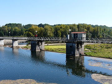
Railway bridge over the Dordogne near Mauzac
.jpg)
_port.jpg)
_barrage_(2).jpg)
.jpg)
_pont_ferroviaire_(4).jpg)
literature
- G. Karnay et al .: Le Bugue . In: Carte géologique de la France at 1/50 000 . BRGM, 1999.