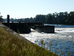
Bergerac weir
| Bergerac weir | |||||||||
|---|---|---|---|---|---|---|---|---|---|
| Downstream of the Bergerac weir | |||||||||
|
|||||||||
|
|
|||||||||
| Coordinates | 44 ° 50 '47 " N , 0 ° 27' 17" E | ||||||||
| Data on the structure | |||||||||
| Lock type: | Run-of-river power plant | ||||||||
| Height above valley floor: | 5.40 m | ||||||||
| Crown length: | 165 m | ||||||||
| Power plant output: | 1.4 MW | ||||||||
| Right side of the valley | |||||||||
The Bergerac weir is a dam in the central Dordogne near Bergerac in the Dordogne department ( Nouvelle-Aquitaine region ).
etymology
The Bergerac weir, French Barrage de Bergerac , is named after the Bergerac sub-prefecture .
geography
The weir is located in the Salvette district of the city of Bergerac and is therefore sometimes referred to as the Salvette weir or the Grand-Salvette weir (French Barrage de Salvette or Barrage de Grand-Salvette ). It is the last dam on the Dordogne before it flows into the Garonne and is 200 meters before the confluence of the Caudeau on the right . The weir serves as a secondary electricity generation, EDF holds the concession for this until 2041. The modest turbine system is located on the right bank of the Dordogne.
history
The construction of the weir began in 1839 to create a reservoir and at the same time to facilitate the maneuverability of the gabarren in the port of Bergerac through a greater draft of 2.25 meters. The work was completed in 1854. A lock enabled ship traffic to bypass the obstacle on the right side of the valley. After a railway line was laid along the Dordogne in the second half of the 19th century, the transport of goods on the Dordogne by means of gabarren consequently declined drastically, so that shipping above Bergerac came to a complete standstill from 1926 onwards.
The generation of energy at the weir did not begin until 1966, after turbines were installed in place of the lock.
description
The dam at the Bergerac weir is 165 meters long and 5.40 meters high.
The electrical output of the run-of-river power plant, which is equipped with two turbines , is rather low at 1.4 MW.
geology
The valley low of the Dordogne, which flows westwards, is 6 to 7 kilometers wide at Bergerac and is filled with worm-age alluvium , into which the river now cuts. The alluvium is generally 6 meters thick, but can reach up to 12 meters in places. At its base it consists of gravel with 3 to 7 centimeters large boulders made of silicon-rich metamorphic rocks and other crystalline rocks. These obviously come from the Massif Central, more than 100 kilometers away . In the hanging walls of the worm terrace , 1 to 1.5 meters thick clays and silt of brown color appear. The valley, in which the Dordogne meanders in places, is bordered by continental molasses of the Tertiary . These also form the deeper subsoil of the Dordogne valley below the alluvium.
ecology
In order not to hinder the fish (mainly alosa , lampreys and salmon ) in their passage, a fish ladder was built in as early as 1855 , which was then further improved in 1872 and 1887. The staircase is over 70 meters long and contains pools connected in series. At that time it was the longest fish ladder in Europe. In order to be able to guarantee its efficiency even at low water levels, further changes were made between 2009 and 2010. The young eels were a cause for concern , for whom a separate climbing system was installed on the left side of the valley.
literature
- J.-P. Platel: Bergerac . In: Carte géologique de la France at 1/50 000 . BRGM, 1985.


