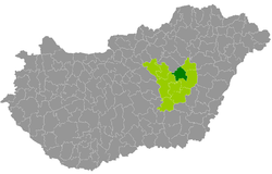
Kunhegyes County
| circle Kunhegyesi járás
Kunhegyes |
|
|---|---|
 Location of the district in Hungary |
|
| Basic data | |
| Country | Hungary |
| County | Jász-Nagykun-Szolnok |
| Seat | Kunhegyes |
| surface | 464.6 km² |
| Residents | 20,106 (January 1, 2016) |
| density | 43 inhabitants per km² |
Kunhegyes (Hungarian Kunhegyesi járás ) is a district within the central Hungarian county Jász-Nagykun-Szolnok . It borders on the Szolnok District in the west, Törökszentmiklós District in the southwest , Karcag District in the southeast and Tiszafüred District in the northeast . In the northwest, Heves county forms the border.
history
The district was newly created in early 2013 for the Hungarian administrative reform. The small area Tiszafüred (Hungarian Tiszafüredi kistérség ) gave 6 of its 13 municipalities in the southwest to the new district. This corresponded to 54.9% of the area and 53.4% of the population of the small area. The new district was strengthened by a municipality from the southern district of Törökszentmiklós.
Community overview
Kunhegyes County has an average parish size of 2,872 inhabitants in an area of 66.37 square kilometers. The population density of the second poorest district is the second lowest in the county. The administrative center is located in the largest city, Kunhegyes , in the southeast of the district.
| local community | status | Origin small area |
population | Area (km²) | Population density (inh / km²) |
||
|---|---|---|---|---|---|---|---|
| October 01, 2011 | 01/01/2013 | 01/01/2016 | |||||
| Abádszalók | city | Tiszafured | 4,180 | 4,328 | 4,160 | 132.23 | 31.5 |
| Kunhegyes | city | Tiszafured | 7,704 | 7,748 | 7,645 | 148.93 | 51.3 |
| Tiszabő | local community | Törökszentmiklós | 1,983 | 2,095 | 2,100 | 35.04 | 59.9 |
| Tiszabura | local community | Tiszafured | 2,895 | 2,933 | 2,970 | 45.20 | 65.7 |
| Tiszagyenda | local community | Tiszafured | 998 | 1,020 | 953 | 36.93 | 25.8 |
| Tiszaroff | local community | Tiszafured | 1,569 | 1,571 | 1,522 | 52.49 | 29.0 |
| Tomajmonostora | local community | Tiszafured | 716 | 739 | 756 | 13.76 | 54.9 |
| Kunhegyes County | 20,045 | 20,434 | 20,106 | 464.58 | 43.3 | ||
swell
PDF and XLS files: 2011
Census :
2013:; 2016:
Individual evidence
- ↑ KSH: 2011. Évi Népszámlálás. In: 3. Területi adatok. KSH, accessed on December 26, 2016 (Hungarian, also via: http://www.terezvaros.hu/testuleti/nepsz2011-3/pdf/nepsz2011_03_16.pdf ).
- ↑ KSH: Regional data - Jász-Nagykun-Szolnok county. KSH, accessed on December 27, 2016 (English, 4th Data on Localities).
- ↑ KSH: Gazetteer of Hungary, 1st January, 2013. KSH, accessed on March 29, 2017 (Hungarian / English).
- ↑ KSH: Gazetteer of Hungary, 1st January, 2016. KSH, accessed on March 29, 2017 (Hungarian / English).