
Kreuzeck (Wetterstein Mountains)
| Kreuzeck | ||
|---|---|---|
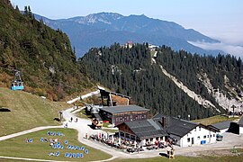
 Kreuzeck with Kreuzeckhaus above Garmisch-Partenkirchen (2006) |
||
| height | 1651 m above sea level NHN | |
| location | Bavaria , Germany | |
| Mountains | Wetterstein Mountains | |
| Coordinates | 47 ° 27 '12 " N , 11 ° 4' 50" E | |
|
||

The Kreuzeck is a mountain 4 km south of Garmisch-Partenkirchen with a height of 1651 m above sea level. NHN .
The Kreuzeck ski area at 1340 m above sea level. NHN Höhe was laid out on the occasion of the 1936 Winter Olympics . The Kandahar run , which is also located there, is now used for World Cup races . The Kreuzeck can be reached with the Kreuzeckbahn . The Kreuzeckhaus is directly connected to it . The VHF radio and television station Garmisch / Kreuzeck is also located on the Kreuzeck , broadcasting five radio programs and twelve television programs via DVB-T for the Garmisch-Partenkirchen region.
tourism
Winter: ski area
Summer: panoramic mountain with easy hikes to the Hochalm or Kreuzalm huts and transition to the Alpspitze . Starting point for a demanding mountain hike via Hupfleitenjoch and Knappenhäuser to the Höllentalangerhütte and into the Höllental .
Directions: Stop of the Bavarian Zugspitzbahn .
View over Hochalm and Hochalmbahn to Kreuzeck (2010)

Osterfelderkopf and Kreuzeck seen from the Alpspitze

