Kronach (Hasslach)
| Kronach | ||
|
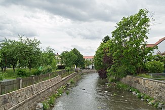
The Kronach am Kaulanger in Kronach |
||
| Data | ||
| Water code | DE : 241446 | |
| location | Germany | |
| River system | Rhine | |
| Drain over | Haßlach → Rodach → Main → Rhine → North Sea | |
| origin | Confluence of the Kremnitz and Grümpel near Wilhelmsthal 50 ° 17 ′ 52 ″ N , 11 ° 22 ′ 0 ″ E |
|
| Source height | 356 m above sea level NN | |
| muzzle | near Kronach in the Haßlach coordinates: 50 ° 14 ′ 13 ″ N , 11 ° 19 ′ 14 ″ E 50 ° 14 ′ 13 ″ N , 11 ° 19 ′ 14 ″ E |
|
| Mouth height | approx. 305 m above sea level NN | |
| Height difference | approx. 51 m | |
| Bottom slope | approx. 6.4 ‰ | |
| length | 7.9 km (with Kremnitz and Finsterbach 27.6 km) | |
| Catchment area | 124.15 km² | |
| Discharge at the Steinberg A Eo gauge : 94.3 km². Location: 7.9 km above the mouth |
NNQ (07/13/1976) MNQ 1948–2006 MQ 1948–2006 Mq 1948–2006 MHQ 1948–2006 HHQ (12/28/1947) |
8 l / s 106 l / s 1.61 m³ / s 17.1 l / (s km²) 23.6 m³ / s 58.4 m³ / s |
|
The confluence of the Kronach (right) and the Haßlach (left). Both rivers are flooding that was caused by the rains that the 2013 European floods led |
||
The Kronach is about eight kilometers long river in the Upper Franconian district of Kronach , which from the confluence of Kremnitz and Grümpel arises. It was first mentioned in the 15th century with the name "Cranach".
geography
course
The Kronach is created by the confluence of the Kremnitz and Grümpel rivers south of Wilhelmsthal . It initially flows in a southerly direction through the villages of Steinberg and Friesen . From there it flows in a south-westerly direction through Dörfles to Kronach , where it joins the Haßlach after a total of eight kilometers from the left .
Spring streams
- Kremnitz
The Kremnitz rises northeast of Reichenbach and flows through the towns of Geschwend and Gifting until it joins the Grümpel after about 17.6 kilometers south of Wilhelmsthal.
- Grumpy
The Grümpel rises south of the community Tschirn and flows about 12.5 kilometers through Effelter and Wilhelmsthal ; south of Wilhelmsthal it joins the Kremnitz to form the Kronach.
Tributaries
- Eibensbach ( left ), Wilhelmsthal- Steinberg, 350 m above sea level. NN
- Tiefenbach ( left ), Wilhelmsthal-Steinberg, 348 m above sea level. NN
- Trebesbach, ( right ), Wilhelmsthal-Steinberg, 348 m above sea level. NN
- Remschlitz ( left ), Kronach- Friesen, 329 m above sea level. NN
- Hainbach ( right ), Kronach-Dörfles, 325 m above sea level. NN
River systems
- Own river system
- Hasslach river system
Web links
- Gauge near Steinberg, HND Bavaria
Individual evidence
- ↑ Directory of stream and river areas in Bavaria - Main river area, page 18 of the Bavarian State Office for the Environment, as of 2016 (PDF; 3.3 MB)
- ↑ Directory of stream and river areas in Bavaria - Main river area, page 19 of the Bavarian State Office for the Environment, as of 2016 (PDF; 3.3 MB)
- ^ Deutsches Gewässerkundliches Jahrbuch Rheingebiet, Part II 2006 Bavarian State Office for the Environment, p. 74, accessed on October 4, 2017, from: bestellen.bayern.de (PDF, German, 23.6 MB).

