
Kruszyniany
| Kruszyniany | |||
|---|---|---|---|

|
|
||
| Basic data | |||
| State : | Poland | ||
| Voivodeship : | Podlaskie | ||
| Powiat : | Sokólski | ||
| Gmina : | Krynki | ||
| Geographic location : | 53 ° 11 ' N , 23 ° 49' E | ||
| Height : | 138-157 m npm | ||
| Residents : | 160 (2006) | ||
| Telephone code : | (+48) 85 | ||
| License plate : | BSK | ||

Kruszyniany ( Belarusian Крушыняны ) is a village in the municipality of Krynki in the powiat Sokólski of the Podlaskie Voivodeship in Poland .
history
The village was probably founded in the 16th century. In 1679 Muslim Lipka Tatars were in the area by the Polish King John III. Sobieski settled. Kruszyniany was then an important center for Muslims. In 1915 the inhabitants were evacuated into the interior of Russia, not all came back after 1918. In 1921 the community had 54 houses with 364 inhabitants, 201 Poles, 142 Belarusians, 21 Jews, 170 Orthodox, 141 Roman Catholic, 32 Muslim, 21 Israelite. In 1980 the village had 289 inhabitants, most of them Belorussian- speaking (locally called simple language ), 33 of whom were Muslim.
From 1975 to 1998 Kruszyniany was part of the Białystok Voivodeship .
Attractions
- Wooden mosque, built in the late 18th century
- Muslim cemetery
- Orthodox church, built in 1984–1985 on the site of the church from 1829
Personalities
- Samuel Murza Krzeczowski, colonel of the Crown Army , commander of the Lipka Tatars, saves King John III. Sobieski's life in the Battle of Párkány
Views
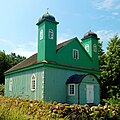
mosque

graveyard

graveyard

Orthodox Church


Individual evidence
- ↑ Крушыняны, вёска . In: www.radzima.net . Retrieved June 21, 2016.