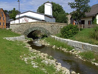
Kupferbach (Tannbach)
|
Kupferbach Töpener Bach / Töpenbach |
||
|
The Kupferbach in Töpen |
||
| Data | ||
| Water code | DE : 561562 | |
| location | Saale-Orla district , Hof district | |
| River system | Elbe | |
| Drain over | Tannbach → Saale → Elbe → North Sea | |
| source | between Misslareuth and Gebersreuth 50 ° 25 ′ 59 ″ N , 11 ° 54 ′ 30 ″ E |
|
| Source height | approx. 620 m | |
| muzzle | north of Töpen in den Tannbach Coordinates: 50 ° 23 '55 " N , 11 ° 51' 36" E 50 ° 23 '55 " N , 11 ° 51' 36" E |
|
| Mouth height | approx. 460 m | |
| Height difference | approx. 160 m | |
| Bottom slope | approx. 17 ‰ | |
| length | 9.2 km | |
| Communities | Gefell , Feilitzsch , Töpen | |
The Kupferbach , also called Töpener Bach or Töpenbach on some maps , is a creek about nine kilometers long in the border area between the Saale-Orla district in Thuringia and the Bavarian district of Hof . It rises between the villages of Mißlareuth (municipality of Weischlitz ) and Gebersreuth (town of Gefell ), initially flows south and at the Drei-Freistaaten-Stein it forms the border between Bavaria and Thuringia for a few meters, then between Bavaria and Saxony, after which it runs up Bavarian area. From Münchenreuth it turns to the south-west and in the local area of Töpen in a curve to the north, to flow below the place into the Tannbach .
Individual evidence
- ↑ Water body indicators , water length and further information about water bodies in Bavaria at the Bavarian State Office for the Environment ( Memento of the original from April 9, 2005 in the web archive archive.today ) Info: The archive link was automatically inserted and not yet checked. Please check the original and archive link according to the instructions and then remove this notice.

