KwaMhlanga
| KwaMhlanga | ||
|---|---|---|
|
|
||
| Coordinates | 25 ° 22 '58 " S , 28 ° 43' 10" E | |
| Basic data | ||
| Country | South Africa | |
| Mpumalanga | ||
| District | Nkangala | |
| ISO 3166-2 | ZA-MP | |
| local community | Thembisile Hani | |
| height | 1325 m | |
| surface | 6.9 km² | |
| Residents | 7123 (2011) | |
| density | 1,029.3 Ew. / km² | |
| founding | 1914 | |
|
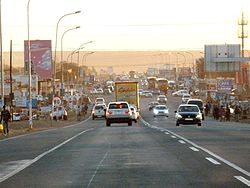
Crossing area R573 / R568
|
||
KwaMhlanga is a city in the South African province of Mpumalanga . It is located in the municipality of Thembisile Hani in the district Nkangala District Municipality . From 1869 to 1994 it was the capital of the homeland of KwaNdebele .
geography
In 2011 KwaMhlanga had 7,123 inhabitants (2011 census). 50% of the population stated that South Ndebele was the first language . The place is 1325 meters above sea level in the largely flat Highveld . A little to the west is the border with Gauteng Province . Immediately to the east of KwaMhlanga are other places with a similar infrastructure.
history
The place was founded in 1914. It developed into the spiritual center of the southern Ndebele , who had been in the area since the 18th century.
Infrastructure
The private Mukhanyo Theological College has its main campus in KwaMhlanga. It is not tied to any particular denomination .
The R573 trunk road runs from Tshwane in the southwest through KwaMhlanga to Siyabuswa in the northeast; the R568 branches off in KwaMhlanga, leads northwards and then also to Siyabuswa.
Web links
- Portrait at sa-venues.com (English)

