
Loser
| Loser | ||
|---|---|---|
 View over Lake Altaussee to the Loser |
||
| height | 1837 m above sea level A. | |
| location | Styria , Austria | |
| Mountains | Dead Mountains | |
| Dominance | 0.5 km → Hochanger | |
| Notch height | 82 m ↓ Scharte to Hochanger | |
| Coordinates | 47 ° 39 '39 " N , 13 ° 46' 16" E | |
|
||
| rock | Tressenstein limestone , layers of Oberalmer | |
| Age of the rock | Upper Jurassic | |
| Development | Loser panorama road | |

The Loser is an 1837 m above sea level. A. high summit in Ausseerland in Styria . It forms the southern end point of the Augstkamm in the Dead Mountains . Its striking, fort-like summit structure made of Tressenstein limestone from the Upper Jura makes it a landmark of the Ausseerland. The Loser is accessible for tourism through the Loser Panorama Road, which opened in 1972 .
Surname
The name Loser comes along that Ausseer rose in the Middle Ages to the mountain summit to (loose: dialect to solve listen [hear, listen]), whether from the Ennstal was to hear sounds of battle.
Development
The mountain can be driven almost to the top on a 9 km toll road. There is a spacious parking lot in front of the Loser restaurant at 1,600 m, from which several tours can be undertaken. At 1,643 m, in the immediate vicinity of the restaurant, is the Augstsee - an attractive hiking destination with a short walking time. From here the path continues, past the Loser window over the Hochanger - to the summit at 1,838 m.
On the Loser, one of the most important ski areas in the Ausseerland extends over 1,000 meters in altitude. The descent leads directly past the Loserhütte (1,498 m), the second restaurant.
Summit cross
The summit cross on the Loser was built in 1963 by members of the general gymnastics club Schwanenstadt (ÖTB). The inauguration took place on September 22, 1963 on the summit plateau. The idea came from Hartmut Dutzler from Schwanenstadt; Karl Pühringer was responsible for the implementation and construction management. The four-part cross was transported to Karl-Eben by the then hut manager Rudolf Loidl with his Puch-Haflinger. From Karl-Eben the cross was transported to the Loserhütte by material cable car. From there the gymnasts carried the cross to the summit. The height of the steel structure is 4 m, the cross beam is 2.03 m long. The total weight is almost 400 kg without the base bracket and fastening material.
Loser window

The Clear window is a naturally formed rock arch and provides a popular photo along the path between the Augstsee and the Clear peaks, just above the upper station of the Clear window chair lift . By the Clear window overlooks the deeper Gschwandtalm in the valley of Rettenbachferner valley and the peak of Schönberg .
Loser solar power plant
There is a photovoltaic system on the Loser southern slope at an altitude of 1,600 m . Due to the pure air and extensive absence of fog and the reflection of snow in winter, there are generally better conditions on mountains to generate solar power. The Loser solar power plant was built from 1988 to 1989 and consists of 598 solar modules with a total surface area of 263.4 m². The module inclination of 60 degrees ensures a balanced energy supply throughout the year. Three units (from the USA, Japan and Germany) deliver around 30 kW of power under optimal conditions, which is fed into the Energie AG network.
Film shoot
In 2008, the Loser was filmed for the thriller The Last Templar with Oscar winner Nicolas Cage and director Dominic Sena .
photos

Panorama Bräuningzinken (left) - Greimuth - Hochanger - Loser (right)

Loose solar power plant
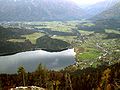
View of Altaussee / Altausseer See

View from Loser Panoramastraße (toll road)
Loser window

Losergipfel seen from Greimuth

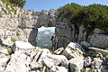
Sissy via ferrata - crossing and key point

Sissy via ferrata - alpinist on the overhang of the key point

Loser seen from Blaa-Alm


Literature & Maps
- Wolfgang Heitzmann: Salzkammergut with the Totem Mountains and Dachstein: high-altitude trails, summit tours, via ferratas . Tour No. 45, pp. 178-181. New edition Bruckmann Verlag, Munich 2002, ISBN 3-7654-3336-5 .
- Alpine Club Map Bl. 15/1 (Totes Gebirge - West), 1: 25,000; Austrian Alpine Club 2014; ISBN 978-3-928777-29-2 .
- ÖK 50 sheet 96 (Bad Ischl), 1: 50,000.
Web links
- Loser ski area
- Solar power plants - Loser (Energie AG)
- Tours
- Hang gliding on the Loser
- Loose panorama via ferrata