
Lüchlekopf
| Lüchlekopf | ||
|---|---|---|
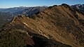
 Eastern Ochsenhofer Kopf (1965 m) with Lüchlekopf from Güntlespitze (2092 m) |
||
| height | 1989 m above sea level A. | |
| location | Vorarlberg , Austria | |
| Mountains | Northwestern Walsertal Mountains , Allgäu Alps | |
| Dominance | 1.3 km → Walmendinger Horn | |
| Notch height | 139 m ↓ Ochsenhofer Scharte | |
| Coordinates | 47 ° 19 '28 " N , 10 ° 6' 40" E | |
|
||
| rock | Flysch of the Üntschendecke | |

The Lüchlekopf (also Muttelbergkopf ) is a 1989 m above sea level. A. high mountain in the Allgäu Alps in the Austrian state of Vorarlberg .
Location and surroundings
The mountain , located in the northwestern Walsertal Mountains subgroup , rises from the ridge that runs from the Walmendinger Horn (1990 m) west to the Grünhorn (2039 m). The direct mountain neighbor in the west is the eastern Ochsenhofer Kopf (1965 m), in the east the Walmendinger Horn. The latter is separated by the Muttelbergscharte (1815 m). In the north is the Schwarzwassertal and at the foot of the southern flank Turabach and Derrenbach merge to form Breitach .
The district on which the Lüchlekopf is located is Mittelberg , which is a little more than three kilometers to the east. The village of Baad is located south of the mountain .
Origin of name
A clear assignment to the origin of the name is not possible. There are mentions in 1793: about the Muttlenberg and in 1818 in a military map : Geisberg, Muttelberg . The first mention is certainly attributable to the Walmendinger Horn, on the military map it is not clear whether alpine huts or mountains are meant. What is certain is that both the Lüchle and the Muttelbergkopf are named after the Alps. For the first variant, the Alpe Lüchle (from "Löchle") should be mentioned.
Ascent
The Schwarzwasserhütte (1620 m) and the Walmendingerhornbahn serve as bases for the ascent of the Lüchlekopf . The normal route leads on a small climb over the Muttelbergscharte initially to a subordinate elevation, also referred to in the literature as the "Muttelbergkopf" (1942 m). From there via the east ridge to the summit, this is sure-footedness necessary. Another access option is from the Schwarzwasserhütte via the Ochsenhofer Scharte (1850 m), Ochsenhofer Köpf and Litzescharte (1875 m) to the summit, here too you need surefootedness .
gallery
Summit construction from the eastern Ochsenhofer head

South-east side of the Liechelkopf
North side of the Hohen Ifen

From the Walmendinger Horn


Web links
Individual evidence
- ↑ Ernst Zettler, Heinz Groth: Alpine Club Guide - Allgäu Alps. 12th, completely revised edition. Bergverlag Rudolf Rother, Munich 1985, ISBN 3-7633-1111-4 (p. 509).
- ↑ a b Thaddäus Steiner : Allgäu mountain names . 2nd Edition. Kunstverlag Josef Fink, Lindenberg 2008, ISBN 978-3-8987-0389-5 (p. 147).
- ↑ Dieter Seibert: Alpine Club Guide alpine - Allgäu Alps and Ammergau Alps . 17th edition. Bergverlag Rother, Munich 2008, ISBN 978-3-7633-1126-2 (p. 176).