
Eastern Ochsenhofer head
| Eastern Ochsenhofer head | ||
|---|---|---|
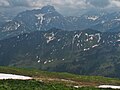
 Eastern Ochsenhofer head from the west summit (1950 m) |
||
| height | 1965 m above sea level A. | |
| location | Vorarlberg , Austria | |
| Mountains | Northwestern Walsertal Mountains , Allgäu Alps | |
| Dominance | 0.4 km → Lüchlekopf | |
| Notch height | 45 m ↓ notch to the Lüchlekopf | |
| Coordinates | 47 ° 19 '28 " N , 10 ° 6' 14" E | |
|
||
| rock | Flysch of the Üntschendecke | |

The eastern Ochsenhofer head is 1965 m above sea level. A. high mountain peak in the Allgäu Alps in the Austrian state of Vorarlberg .
Location and surroundings
The mountain , located in the northwestern Walsertal Mountains subgroup , rises from the ridge that runs from the Walmendinger Horn (1990 m) west to the Grünhorn (2039 m). The direct mountain neighbor to the west is the western Ochsenhofer head (1950 m), separated by the Litzescharte (1875 m), with which it forms the Ochsenhofer head . To the east is the Lüchlekopf (1989 m), to which it is connected via a notch, which is the reference for the notch height of at least 45 meters. In the north is the Schwarzwassertal and at the foot of the southern flank the Turabach flows towards the Breitach .
The district on which the eastern Ochsenhofer Kopf is located is Mittelberg , which is a little more than three and a half kilometers to the east. To the southeast of the mountain lies the village of Baad .
Origin of name
The Ochsenhofer heads are mentioned for the first time in 1783 in Blasius Hueber's Vorarlberg map : Ochsenhöfer Kopf . Also in the Schmitt'schen card one is 1797 ox head noted. It was named after the Alpe Ochsenhof on the northern flanks of the mountains, which is divided into Melkochsenalpe and Galtochsenalpe. In a military map from 1818, Stierhofer K. is also used for the east summit .
Ascent
The Schwarzwasserhütte (1620 m) and the Walmendingerhornbahn serve as bases for the ascent of the eastern Ochsenhofer Kopf .
summer
Usually the summit is entered when crossing the ridge. On a small climb it goes from the Muttelbergscharte with surefootedness over the Lüchlekopf and the notch in between to the summit. Another access option is from the Schwarzwasserhütte via the Ochsenhofer Scharte (1850 m), the western Ochsenhofer Kopf and the Litzescharte to the summit.
winter
Even in winter, the Eastern Ochsenhofer Kopf can be climbed as part of a ski tour . The route leads over the Melkochsenalpe and the Litzescharte.
gallery

From the east
North side of the Hohen Ifen

South flank


Web links
Individual evidence
- ↑ Ernst Zettler, Heinz Groth: Alpine Club Guide - Allgäu Alps. 12th, completely revised edition. Bergverlag Rudolf Rother, Munich 1985, ISBN 3-7633-1111-4 (p. 509).
- ↑ Exact value not known, stated value is a minimum value (can be up to 19 meters higher). It was determined from the distance between the contour lines (20 meters in altitude ) on a topographic map ( scale 1: 25,000).
- ^ Thaddäus Steiner : Allgäu mountain names . 2nd Edition. Kunstverlag Josef Fink, Lindenberg 2008, ISBN 978-3-8987-0389-5 (p. 150).
- ↑ Dieter Seibert: Alpine Club Guide alpine - Allgäu Alps and Ammergau Alps . 17th edition. Bergverlag Rother, Munich 2008, ISBN 978-3-7633-1126-2 (p. 176).
- ↑ Kristian Rath: Allgäu ski tour guide with Kleinwalsertal and Tannheimer Tal . 6th edition. Panico Alpinverlag, Köngen 2009, ISBN 978-3-9367-4010-3 (p. 31.).