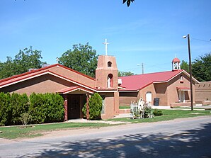
La Luz (New Mexico)
| La Luz | ||
|---|---|---|
 Our Lady of the Light chapel |
||
| Location in New Mexico | ||
|
|
||
| Basic data | ||
| State : | United States | |
| State : | New Mexico | |
| County : | Otero County | |
| Coordinates : | 32 ° 59 ′ N , 105 ° 57 ′ W | |
| Time zone : | Mountain ( UTC − 7 / −6 ) | |
| Residents : | 1,697 (as of 2010) | |
| Population density : | 61 inhabitants per km 2 | |
| Area : | 27.8 km 2 (approx. 11 mi 2 ) | |
| Height : | 1448 m | |
| Postcodes : | 88337 | |
| Area code : | +1 575, 505 | |
| FIPS : | 35-38330 | |
| GNIS ID : | 0920624 | |
La Luz is a community and a census-designated place (CDP) in Otero County in the US state of New Mexico .
geography
La Luz borders Alamogordo immediately to the north . About 100 kilometers to the southwest is Las Cruces . The connecting roads US Highway 54 and US Highway 70 , which are identical in this section, run through the village . To the east are the Sacramento Mountains .
history
The first settlers in the region were Franciscan missionaries from Spain . They built a chapel around 1719 and called her Our Lady of the Light (span: Nuestra Senora de la Luz ). The name of the city was derived from the Spanish La Luz (The Light). Other settlers followed into the fertile area and founded farms for fruit and wine growing. In addition, were pottery and weavings founded. Artists, especially painters, also settled in the place. In 1898 a railway line of the El Paso and Northeastern Railroad reached the city of Alamogordo and in the following years was extended further into the mountains as the Alamogordo and Sacramento Mountain Railway to Cloudcroft , which is 2,640 meters high , with La Luz also having a station. The line was also known as the Cloud Climbing Railroad because of the exceptional altitude for a railway station at that time (right up into the clouds) . Many historically valuable buildings were subsequently constructed and are now on the National Register of Historic Places . These include the DH Sutherland House , the Queen Anne House , the Juan Garcia House , the La Luz Pottery Factory and the historic city center ( La Luz Historic District ).
The main employers in La Luz today are still fruit and wine-growing companies, as well as Holloman Air Force Base , which is around 20 kilometers south . Tours to the nearby White Sands National Monument are also offered.
Demographics
In 2010 a population of 1697 people was determined, which means an increase of 5.1% compared to the year 2000. The mean age of the residents in 2010 was 43.5 years, slightly below the mean of New Mexico, which was 45.5 years.
34.2% of today's residents are of Hispanic origin. Other significant immigrant groups during the city's early days came from Germany (11.5%) and Ireland ( 7.4%) .
Individual evidence
- ↑ US Postal Service - ZIP Codes
- ↑ History ( Memento of the original from February 17, 2014 in the Internet Archive ) Info: The archive link was inserted automatically and has not yet been checked. Please check the original and archive link according to the instructions and then remove this notice.
- ^ Cloud Climbing Railroad
- ^ L city data La Luz


