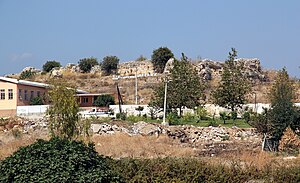
Lamos Kalesi
| Lamos Kalesi | ||
|---|---|---|
|
Lamos Kalesi from the southeast |
||
| Alternative name (s): | Llamas, Λάμος | |
| Creation time : | High Middle Ages | |
| Castle type : | Hilltop castle | |
| Conservation status: | ruin | |
| Construction: | Cuboid | |
| Place: | Limonlu | |
| Geographical location | 36 ° 33 '26 " N , 34 ° 14' 28" E | |
| Height: | 18 m | |
|
|
||
Lamos Kalesi is a high to late medieval castle ruin in the historic landscape of Cilicia in the Erdemli district of the Turkish province of Mersin .
location
Lamos Kalesi is located in Limonlu (formerly Lamos, also Lamas or Lamaws , Greek Λάμος , Hittite : Lamiya) on the Limonlu Çayı river of the same name (ancient also Lamos) , which in ancient times marked the border between the plains (Kilikia Pedias) and the rough Cilicia (Kilikia Tracheia) formed on a flat limestone hill that rises on the right, western bank of the Limonlu River in the north of the village. About 500 meters to the east, the river flows into the Mediterranean. An aqueduct begins in the north-west of the village and carried water from the Lamos River to Elaiussa Sebaste and Korykos in the south-west. The area around the place was called Lamousia .
The place should not be confused with the Lamos of the same name , which lies further west on the border between Cilicia and Isauria and whose surroundings are called Lamotis.
history
Strabo mentions the place Lamos at the mouth of the river of the same name. In the 9th and 10th centuries, Muslims and Byzantines met on the site several times for the purpose of exchanging prisoners. According to Hellenkemper / Hild, the first of these meetings took place in 797, according to other sources in 805 during the reign of the caliph Hārūn ar-Raschīd and the Byzantine emperor Nikephoros I. In 1158, the Byzantine emperor Manuel I conquered the castle. In 1164/65 the Armenian Vasak is documented as prince of Asguras and Lamaws . Later the fortress passed into Ottoman ownership.
description
The ring wall of the castle encloses a west-east lying rectangle with an area of about 40 × 80 meters. Two construction phases can be seen. The Armenian complex had semicircular protruding bastions , one of which can still be seen in the southeast corner. In the Ottoman period, rectangular bastions were built over them; the western part was completely renovated. Today only low remains of the enclosing wall with traces of a rectangular, inwardly open bastion in the north, south and west are preserved. Only a few spolia from the ancient town of Lamos can be found in the area .
literature
- Friedrich Hild , Hansgerd Hellenkemper : Kilikien and Isaurien. Tabula Imperii Byzantini Volume 5. Publishing house of the Austrian Academy of Sciences, Vienna 1990, ISBN 3-7001-1811-2 , pp. 330–331.
- Hansgerd Hellenkemper: Crusader castles in the county of Edessa and in the Kingdom of Lesser Armenia. (= Geographica Historica 1 ) Habelt, Bonn 1976, ISBN 3-7749-1205-X , pp. 240-242
Web links
Individual evidence
- ↑ Philipp Pilhofer: Early Christianity in the Kilikisch-Isaurischen Bergland = texts and studies on the history of early Christian literature (TU) Volume 184. De Gruyter 1918 ISBN 978-3-11-057381-7 p. 15 note 7.
- ↑ Strabo, Christoph Gottlieb Groskurd: Earth description: In seventeen books: based on corrected Greek texts ... Nicolai, 1833, p. 80 ( limited preview in Google Book search).
- ↑ Cl. Huart: Lamas-Ṣū In: The Encyclopaedia of Islam. New Edition . Vol. 5, Brill, Leiden, p. 647.

