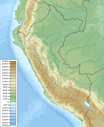
Lampa (Peru)
| Lampa | ||
|---|---|---|
|
|
||
| Coordinates | 15 ° 22 ′ S , 70 ° 22 ′ W | |
| Basic data | ||
| Country | Peru | |
| Puno | ||
| province | Lampa | |
| ISO 3166-2 | PE-PUN | |
| District | Lampa | |
| height | 3892 m | |
| Residents | 5649 (2017) | |
| Website | munilampa.gob.pe (Spanish) | |
| politics | ||
| mayor | Ciriaco Isidro Diaz Arestegui (2019-2022) |
|
|
Aerial view of Lampa
|
||
Lampa is the capital of the Lampa Province in the Puno region in southern Peru . Lampa is in the district of the same name . The city had 5649 inhabitants at the 2017 census. 10 years earlier the population was 4949.
Geographical location
The city of Lampa is located on the Altiplano west of Lake Titicaca . It lies at an altitude of 3892 m . The west bank of Lake Titicaca is 45 km away. The Río Lampa flows southwest of the city. The Laguna Colorada lake is located northeast of the city. The city of Juliaca is located about 30 km southeast of Lampa.
Individual evidence
- ↑ a b PERU: Region Puno - Provinces & Places . www.citypopulation.de. Accessed December 31, 2019.
Web links
Commons : Lampa - collection of images, videos and audio files


