Lampa Province
| Lampa Province | |
|---|---|
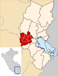
 Location of the province in the Puno region |
|
| Basic data | |
| Country | Peru |
| region | Puno |
| Seat | Lampa |
| surface | 5792 km² |
| Residents | 40,856 (2017) |
| density | 7.1 inhabitants per km² |
| ISO 3166-2 | PE-PUN |
| Website | www.munilampa.gob.pe (Spanish) |
| politics | |
| Alcalde Provincial | Ciriaco Isidro Díaz Arestegu (2019-2022) |
| Aerial view of Lampa | |
Coordinates: 15 ° 22 ′ S , 70 ° 22 ′ W
The province of Lampa belongs to the administrative region of Puno in the south of Peru . It has an area of 5792 km². The 2017 census counted 40,856 inhabitants in the province. Ten years earlier the population was 43,461. The administrative seat is in Lampa .
Geographical location
The province of Lampa is located in the west of the Puno region. The province is west of Lake Titicaca . In the north it borders on the province of Melgar , in the east on the province of Azángaro , in the south on the province of San Román and in the west on the regions of Arequipa and Cusco .
Administrative division
The province of Lampa consists of 10 districts. The Lampa district is the seat of the provincial administration.
| District | Administrative headquarters |
|---|---|
| Cabanilla | Cabanilla |
| Calapuja | Calapuja |
| Lampa | Lampa |
| Nicasio | Nicasio |
| Ocuviri | Ocuviri |
| Palca | Palca |
| Paratía | Paratía |
| Pucará | Pucará |
| Santa Lucía | Santa Lucía |
| Vilavila | Vilavila |
Individual evidence
- ↑ a b c Lampa, Province in Peru . www.citypopulation.de. Retrieved November 22, 2019.
Web links
Commons : Province of Lampa - Collection of images, videos and audio files
