Vilavila district
| Vilavila district | |
|---|---|
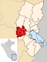
 The district of Vilavila is located west-north of the province of Lampa (marked in red) |
|
| Basic data | |
| Country | Peru |
| region | Puno |
| province | Lampa |
| Seat | Vilavila |
| surface | 161 km² |
| Residents | 1308 (2017) |
| density | 8.1 inhabitants per km² |
| founding | May 2, 1854 |
| ISO 3166-2 | PE-PUN |
| politics | |
| Alcalde District | Rogato Modesto Pacco Cutipa (2019-2022) |
Coordinates: 15 ° 11 ′ S , 70 ° 40 ′ W
The Vilavila district is located in the Lampa province in the Puno region in southern Peru . The district was founded on May 2, 1854. It has an area of 161 km². In the 2017 census, 1308 inhabitants were counted. In 1993 the population was 755, in 2007 it was 2380. The district administration is located in the 4,300 m high village of Vilavila with 513 inhabitants (as of 2017). Vilavila is located 37 km northwest of the provincial capital Lampa .
Geographical location
The Vilavila district is located in the Andean highlands in the western north of the Lampa province. The Río Vilavila, left source river of the Río Lampa (also Río Palca), flows along the southern district boundary to the east and drains the area. In the north-west there is a smaller, up to 5100 m high mountain range with the peaks Zapnsalla and Llanquerani. A ridge runs east of this along the northern district border, which forms the watershed to the Río Pucará , which flows further north .
The Vilavila district borders on the Ocuviri district to the west , the Ayaviri district ( Melgar province ) to the north and east and the Palca district to the south .
Web links
- Peru: Region Puno (provinces and districts) at www.citypopulation.de
- INEI Perú