Cabanilla district
| Cabanilla district | |
|---|---|
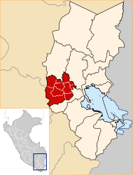
 The Cabanilla district is located in the southeast of the Lampa province (marked in red) |
|
| Basic data | |
| Country | Peru |
| region | Puno |
| province | Lampa |
| Seat | Cabanilla |
| surface | 385 km² |
| Residents | 5848 (2017) |
| density | 15 inhabitants per km² |
| ISO 3166-2 | PE-PUN |
| politics | |
| Alcalde District | Miguel Luciano Mestas Vilca (2019-2022) |
| Political party | Front amplio para el Desarrollo del Pueblo |
| District Administration Building | |
Coordinates: 15 ° 37 ′ S , 70 ° 21 ′ W
The Cabanilla district is located in the Lampa province in the Puno region in southern Peru . The district has an area of 385 km². The 2017 census counted 5848 inhabitants. In 1993 the population was 5545, in 2007 it was 5573. The seat of the district administration is the 3876 m high village of Cabanilla with 1196 inhabitants (as of 2017). Cabanilla is located 28 km south-southeast of the provincial capital Lampa .
Geographical location
The Cabanilla district is located in the southeast of the Lampa province. The Río Coata (also Río Cabanillas) flows northeast along the southern and southeastern district boundaries . The northeast is drained by the Río Lampa .
The Cabanilla district is bordered by the Santa Lucía district to the west, the Lampa district to the north, the Juliaca district to the northeast, the Cabana district to the southeast and the Cabanillas district to the south (the last three districts mentioned belong to the San Román province ).
Web links
- Peru: Region Puno (provinces and districts) at www.citypopulation.de
- INEI Perú

