Nicasio District
| Nicasio District | |
|---|---|
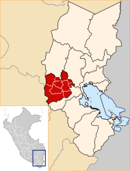
 The district of Nicasio is located in the east of the province of Lampa (marked in red) |
|
| Basic data | |
| Country | Peru |
| region | Puno |
| province | Lampa |
| Seat | Nicasio |
| surface | 133 km² |
| Residents | 2473 (2017) |
| density | 19 inhabitants per km² |
| founding | May 2, 1854 |
| ISO 3166-2 | PE-PUN |
| politics | |
| Alcalde District | Mauro Puma Campos (2019-2022) |
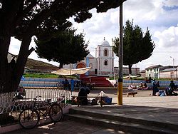
| Church in Nicasio | |
Coordinates: 15 ° 14 ′ S , 70 ° 16 ′ W
The Nicasio district is located in the Lampa province in the Puno region in southern Peru . The district was founded on May 2, 1854. It has an area of 133 km². The 2017 census counted 2,473 inhabitants. In 1993 the population was 2683, in 2007 2756. The seat of the district administration is the 3850 m high village Nicasio with 359 inhabitants (as of 2017). Nicasio is located 18 km northeast of the provincial capital Lampa .
Geographical location
The Nicasio district is located in the Andean highlands in the east of the Lampa province. The east and northeast of the district are in the arid desert plain northwest of Lake Titicaca . The Río Pucará crosses the far west of the district in a south-easterly direction. To the east of the river, two mountains up to 4322 m high rise - Pukarani and Lulicunca. To the west of the river, the district boundary runs over a ridge with the mountains Suapuro and Titili.
The Nicasio district borders on the Lampa district to the west, the Santiago de Pupuja and Achaya districts (both in the Azángaro province ) to the north and east, and the Calapuja district to the south .
Localities
In addition to the main town, the district has the following larger towns:
- Balsapata
- Chullumpi Charamicaya
- Jupari
- Kaquingora
- Larkas (271 inhabitants)
- Laro
Web links
- Peru: Region Puno (provinces and districts) at www.citypopulation.de
- INEI Perú
