Huancané Province
| Huancané Province | |
|---|---|
 Location of the province in the Puno region |
|
| Basic data | |
| Country | Peru |
| region | Puno |
| Seat | Huancané |
| surface | 2806 km² |
| Residents | 60,379 (2017) |
| density | 22 inhabitants per km² |
| founding | September 19, 1827 |
| ISO 3166-2 | PE-PUN |
| Website | www.munihuancane.gob.pe (Spanish) |
| politics | |
| Alcalde Provincial | Jorge Arturo Alvarez Mendoza (2019-2022) |
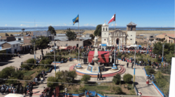
| Plaza de Armas in Pusi | |
Coordinates: 15 ° 5 ′ S , 69 ° 32 ′ W
The province of Huancané belongs to the administrative region of Puno and is located in the south of Peru . The province was founded on September 19, 1827. It has an area of 2806 km². The 2017 census counted 60,379 inhabitants in the province. In 1993 the population was 80,317, in 2007 69,522. The administrative seat is the city of Huancané .
Geographical location
The province of Huancané is located in the east of the Puno region, on the north shore of Lake Titicaca and extends over the arid Andean highlands northeast of the lake. The maximum longitudinal extent in SW-NE direction is about 100 km. The Río Suches , a tributary of Lake Titicaca, runs along the northeastern provincial border with Bolivia . To the east is the neighboring province of Moho . In the southwest the province of Huancané borders on the neighboring provinces of Puno and San Román , in the west and northwest on the provinces Azángaro and San Antonio de Putina .
Administrative division
The Huancané Province consists of the following eight districts. The Huancané district is the seat of the provincial administration.
| District | Administrative headquarters |
|---|---|
| Cojata | Cojata |
| Huancané | Huancané |
| Huatasani | Huatasani |
| Inchupalla | Inchupalla |
| Pusi | Pusi |
| Rosaspata | Rosaspata |
| Taraco | Taraco |
| Vilque Chico | Vilque Chico |
Web links
- Municipalidad Provincial de Huancané
- Peru: Region Puno (provinces and districts) at www.citypopulation.de
- INEI Perú
