
Petrisberg

The Petrisberg zu Trier (known as Martinsberg until at least 1823) is located east of the city center and offers due to its height of approx. 265 m above sea level. NHN some much-visited viewpoints on the city a good hundred meters below.
The Petrisberg bears its name after the owner of a farm in the extension of the modern Sickingenstrasse.
location
In the north it is bounded by the Avelertal in the Kürenz district and in the south by the Olewiger valley. The Tarforst district borders the mountain in the east and the Mitte-Gartenfeld district in the west .
climate
-Deutschland-metrisch-deutsch.png)
On the Petrisberg there is a measuring station of the German Weather Service , which supplies extensive climate data. The precipitation is in the middle third of the values recorded in Germany. Lower values are registered at 60% of the measuring stations of the German Weather Service . The driest month is April, with the most rainfall in November. In November there is 1.4 times more rainfall than in April. Precipitation varies only minimally and is extremely evenly distributed over the year. Lower seasonal fluctuations are recorded at only 1% of the measuring stations.
history

In the year 30 BC After a few months the Romans established a military camp on Petrisberg, which was abandoned after a few months. Founded the city of Augusta Treverorum , ( city of Augustus in the land of the Treveri ), the capital of the province of Belgica . Until the discovery of the Roman garrison camp near Hermeskeil, it was considered the oldest Roman military camp in Germany.
Under the name Petrisberg, the area was primarily used as pasture in the Middle Ages; The field names Lämmerwiese and Geißberg have been preserved from this time. In addition, wine was grown on the Kürenzer and Olewiger slopes, in the Aveler Valley, Brettenbach and the Retzgrube. There is a way of the cross on the Kürenzer slope that ends at the chapel. The Kleeburger Hof farm (below the modern university) has existed since the 15th century.
In 1936 a military complex was built on the Petrisberg. In the Kemmel barracks , which was completed in 1938, the notorious POW camp, Stammlager XII , was built during the Second World War . One of the most famous prisoners in the camp was the French writer Jean-Paul Sartre . After the Allied victory, the area was used as a barracks by the French and the "André Genet" military hospital was added.
In 1950, a new medium-wave transmitter was built by the Trier transmitter on the Petrisberg , which was moved to the Markusberg in 1958. Today the 132 m high telecommunications tower Trier-Petrisberg of the Telekom (a type tower ) is on the Petrisberg.
The Petrisberg also provided the name for a type of beer from the Löwenbrauerei Trier in the 1980s, namely the Petrisberger Pils. With the closure of the Löwen brewery in 1989, the Petrisberger Pils also disappeared.
today

After the withdrawal of the French army, the conversion area was redesigned for the State Garden Show in 2004 , and a new district was created as a mixed area for living, working and living. A total area of approx. 700,000 square meters is divided into residential areas, a science park and leisure areas. Thanks to the former state horticultural show, many leisure activities have been retained, such as the Lotto Forum, a small covered open-air stage where performances take place in the summer months, the skate park, the beach volleyball courts and the water playground.
economy
The WIP Wissenschaftspark Trier unites around 180 resident companies with around 1200 employees, mainly from the fields of healthcare, research and science, services as well as media and IT.
Attractions
Above the Trier amphitheater is the most important vantage point from which one can get an overview of the city and to the west into the Moselle valley. It is particularly popular with visitors to the city in the summer months, as it can be reached by car or bus. On the mountain is the former St. Klara monastery and a nursing home for nuns.
On the Petrisberg, the “Kreuzchen” station path ends at the “Zum Kreuzchen” chapel, which was built in 1844 and inaugurated in 1847. Near the chapel is Franzensknppchen , a barrow from Roman times, from which a legend according to Franz von Sickingen is said to have shot at Trier in 1522, but this could not be possible due to the range of the weapons at that time.
On Petrisberg, in Sickingenstrasse above the amphitheater, the Trier Wine Culture Trail begins, which leads through the vineyards to the Olewig district . Here the work of the winemaker is explained and information about the winemaking tradition of the city of Trier is given. There are daily guided tours after registration.
The district has a lot of leisure, sightseeing and recreational opportunities to offer such as the partner gardens, the Wasserband, the Lotto Forum, the Luxembourg Tower and the Water Tower. The mixed area also offers architectural sights such as the WIP Center or the old tank repair workshop. From the Hotel Petrisberg, where Willy Brandt and Helmut Schmidt stayed , there is a unique view over Trier.
The so-called water band in the Petrisberg construction area is also worth seeing. Its task is to ensure the retention and infiltration of rainwater with the associated retention areas .
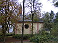
Chapel "Zum Kreuzchen"

Chapel "Zum Kreuzchen"

Chapel "Zum Kreuzchen"

Memorial to the Japanese student Mutsuko Ayano who was murdered here

Water band in the Petrisberg construction area

Completed water band with water tower at night

Summer thunderstorm over the Petrisberg

Water tower, aerial photo (2016)

Luxembourg Tower

Luxembourg tower at night

View from the Kockelsberg


Individual evidence
- ↑ a b c “Reiner Nolden, Trier City Archives, on the homepage of the Trier State Garden Show 2004” according to the entry on Petrisberg - history in the database of cultural assets in the Trier region ; accessed on February 27, 2016.
- ↑ Geoclimate 2.1
- ↑ The oldest Roman military camp discovered . In: Schwäbische Zeitung of September 10, 2012
Web links
- Landesgartenschau Trier 2004 on the Petrisberg ( Memento from September 16, 2010 in the Internet Archive )
- Perspective Petrisberg ( Memento from January 18, 2013 in the Internet Archive )
- New Petrisberg
Coordinates: 49 ° 45 ' N , 6 ° 40' E