Laudach
| Laudach | ||
|
The Laudach in winter. |
||
| Data | ||
| location | Upper Austria | |
| River system | Danube | |
| Drain over | Alm → Traun → Danube → Black Sea | |
| source |
Laudachsee 47 ° 52 ′ 51 ″ N , 13 ° 51 ′ 16 ″ E |
|
| Source height | 894 m above sea level A. | |
| muzzle | at Bad Wimsbach in the Alm Coordinates: 48 ° 2 ′ 21 ″ N , 13 ° 55 ′ 15 ″ E 48 ° 2 ′ 21 ″ N , 13 ° 55 ′ 15 ″ E |
|
| Mouth height | approx. 372 m above sea level A. | |
| Height difference | approx. 522 m | |
| Bottom slope | approx. 24 ‰ | |
| length | 22 km | |
| Discharge at the Au gauge (Mittlere Au) A Eo : 72.2 km² Location: 470 m above the mouth |
NNQ (03.08.1992) MNQ 1981–2009 MQ 1981–2009 Mq 1981–2009 MHQ 1981–2009 HHQ (05.09.1987) |
33 l / s 170 l / s 1.18 m³ / s 16.3 l / (s km²) 43.1 m³ / s 118 m³ / s |
| Right tributaries | Inner Laudach | |
| Communities | St. Konrad , Gschwandt , Kirchham , Vorchdorf , Bad Wimsbach | |
|
The Laudach in summer. |
||
The Laudach is a river in the Austrian state of Upper Austria . It is around 22 km long, making it the largest tributary of the Alm .
The larger Äußere Laudach is the outflow of the Laud axis in Gmunden . From the south, it passes through the municipal areas of St. Konrad , Gschwandt , Kirchham and Vorchdorf .
The tributary, the Innere Laudach (or Dürre Laudach ), has its source in the municipality of Kirchham . It is formed from the two source rivers Platzbach and Edlbach . They draw their water from the Wiesberg, Hacklberg and Feichtenberg hills, which are shaped like a horseshoe around the Kirchham district of Hagenmühle. Also coming from the south, this right tributary flows north of the center of Vorchdorf into the (outer) Laudach.
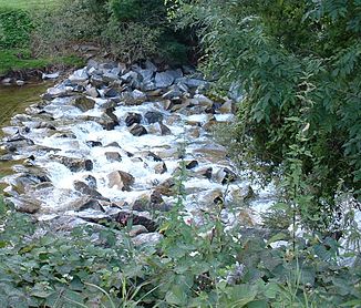
The Laudach flows into the Alm about 5 km after the confluence of the Outer and Inner Laudach rivers, interrupted several times by small weirs , in the southern municipality of Bad Wimsbach .
There are a number of artificially created ponds along the Laudach.
Individual evidence
- ↑ Digital Upper Austrian Room Information System (DORIS)
- ↑ Federal Ministry for Agriculture, Forestry, Environment and Water Management (ed.): Hydrographisches Jahrbuch von Österreich 2009. 117th volume. Vienna 2011, p. OG 182, PDF (12.1 MB) on bmlrt.gv.at (yearbook 2009)
- ↑ Grüß Gott in Kirchham. (No longer available online.) Almtalonline.at, formerly in the original ; Retrieved September 14, 2008 . ( Page no longer available , search in web archives ) Info: The link was automatically marked as defective. Please check the link according to the instructions and then remove this notice.
- ↑ Wilder Bach under the Traunstein. (No longer available online.) Extrablick.at, formerly in the original ; Retrieved September 15, 2008 . ( Page no longer available , search in web archives ) Info: The link was automatically marked as defective. Please check the link according to the instructions and then remove this notice.

