Lauro de Freitas
| Lauro de Freitas | ||
|---|---|---|
|
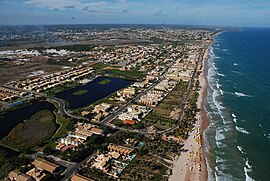
Coordinates: 12 ° 54 ′ S , 38 ° 20 ′ W Aerial view of Lauro de Freitas
|
||
| Basic data | ||
| Country |
|
|
| State |
|
|
| Residents | 156,936 (IBGE 2009) | |
| City insignia | ||
| Detailed data | ||
| surface | 59 km 2 | |
| Population density | 2434 inhabitants / km 2 | |
| height | 30 m | |
| Waters | Atlantic | |
| prefix | (+55) 71 | |
| Time zone | UTC −3 | |
| Website | ||
| Aerial view of Lauro de Freitas | ||
Lauro de Freitas is a Brazilian city in the state of Bahia on the border with Salvador . In the immediate vicinity of the city is also the international airport of Salvador-Magalhães , which can be reached quickly from Lauro de Freitas.
Like Salvador, Lauro de Freitas is located directly on the Atlantic Ocean .
In 2009, according to official IBGE figures, Lauro de Freitas had 156,936 inhabitants with an area of 59 km², which corresponds to a population density of 2,434 inhabitants per km², and is therefore a good twelfth the size of Salvador da Bahia .
Infrastructure
In the city center there are many small shops and the city administration as well as some restaurants and bars. Elegant residential areas such as the Vilas do Atlântico district , on the other hand, consist of guarded housing estates ( condomínios ).
The city and the city center are located directly on the further north toll expectant Estrada do Coco , and 2 km from Salvador airport, which begins on the outskirts.


