Camaçari
| Camaçari | ||
|---|---|---|
|
Coordinates: 12 ° 42 ′ S , 38 ° 19 ′ W Camaçari on the map of Brazil
|
||
| Basic data | ||
| Country |
|
|
| State |
|
|
| City foundation | 1758 | |
| Residents | 242,970 (2010) | |
| City insignia | ||
| Detailed data | ||
| surface | 784.658 km² | |
| Population density | 309.65 inhabitants / km 2 | |
| height | 36 m | |
| Time zone | UTC −3 | |
| City Presidency | Antônio Elinaldo | |
| Website | ||
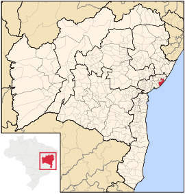
| Location in the state of Bahia | ||
| Guarajuba beach | ||
Camaçari , officially Município de Camaçari , is a city in the Brazilian state of Bahia .
It was founded in 1758 as Vila Nova do Espírito Santo de Abrantes , or Vila Abrantes for short . According to the 2010 census, it had 242,970 inhabitants, in 2019 the population was estimated at 299,132. The area is 784.658 km² with a population density of 309 inhabitants / km² (as of 2010). The city lies at an altitude of 36 meters above sea level. It is limited to the east by the Atlantic Ocean . It belongs to the metropolitan region of Salvador and is around 41 km away from the capital Salvador to the south.
climate
The climate is tropical according to the climate classification according to Köppen and Geiger of the climate type Aw / As with an average temperature of 26 ° C.
economy
With the Polo Industrial de Camaçari industrial park, Camaçari is an important industrial location and bears the city nickname Cidade Industrial . In 1978 the petrochemical complex Polo Petroquímico de Camaçari was opened in the city, comprising more than 90 chemical plants ( Braskem ), the automotive industry ( Ford and Continental AG ), cellulose, copper processing, textile industry, beverage production and services.
tourism
Camaçari has more than 42 km of beaches known as the Coconut Coast. It is accessed by the BA-099 state road , the Estrada do Coco . which leads from Praia do Forte to Lauro de Freitas . On the coast are some of the oldest hippie places, inland there are settlements of the Quilombas . Well-known settlements include Guarajuba , Jauá and Arembepe . Tourism has a high share in the economic life of the municipal city.
Well-known beaches are:
- Praia de Armbepe
- Praia de Barra do Jacuípe
- Busca Vida Beach
- Praia de Guarajuba
- Praia de Genipabu
- Praia de Interlagos
- Praia de Itacimirim
- Praia do Japonês
- Praia de Jauá
sons and daughters of the town
- Fabiano Santacroce (* 1986), football player
- Anselmo Ramon (* 1988), football player
- Maxwell Batista da Silva (* 1989), football player
Web links
Individual evidence
- ^ Instituto Brasileiro de Geografia e Estatística (IBGE): Cidades @ Bahia: Camaçari. Retrieved August 28, 2019.
- ↑ Clima: Camaçari: Climograma, Temperatura e Tabela climática Camaçari. In: climate-data.org. pt.climate-data.org, accessed April 3, 2018 .


