Leelanau Township
| Leelanau Township | ||
|---|---|---|
 Northport Fire Station , 2011 |
||
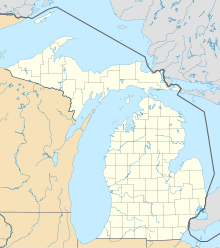
| Location in Michigan | ||
|
|
||
| Basic data | ||
| State : | United States | |
| State : | Michigan | |
| County : | Leelanau County | |
| Coordinates : | 45 ° 9 ′ N , 85 ° 36 ′ W | |
| Time zone : | Eastern ( UTC − 5 / −4 ) | |
| Residents : | 2,234 (as of 2015) | |
| Population density : | 17.5 inhabitants per km 2 | |
| Area : | 588.9 km 2 (approx. 227 mi 2 ) of which 127.3 km 2 (approx. 49 mi 2 ) is land |
|
| Height : | 277 m | |
| Postcodes : | 49670, 49674, 49682 | |
| FIPS : | 26-46700 | |
| GNIS ID : | 1626601 | |
Leelanau Township is a Civil Township in Leelanau County , Michigan .
geography
According to the United States Census Bureau , the township has an area of 589.4 square kilometers. Of this, 127.5 square kilometers are land and 461.9 square kilometers are water. The average altitude is 277 meters above sea level. Leelanau is part of a nature conservation project.
population
According to an official estimate, Leelanau had 2,234 inhabitants in 2015. At the official 2010 census it was 2,027 inhabitants, at the 2000 census it was 2,139.
climate
Leelanau Township is located in the temperate climate zone and has high rainfall throughout the year. The annual average temperature is 7.2 degrees Celsius. The annual rainfall averages 804 mm.
structure
Leelanau Township consists of Northport , a village on Grand Traverse Bay , Omena , an unincorporated area, and Suttons Bay as a village part of the south of the township. A former settlement from 1883 to 1908 was Gills Pier.
