
Lumbar canal


The Lend Canal is a four kilometer long artificial waterway that leads from the Wörthersee to the center of Klagenfurt . Most of it runs parallel to Tarviser Straße in the north (formerly “Lendweg” and “Schiffgasse”). Villacher Straße accompanies him to the south. In the west, the Lend Canal runs from Europapark Klagenfurt and the Minimundus through the so-called "Lendspitz" and flows into Lake Wörthersee at Maria-Loretto Castle . Several bridges cross the canal, some of which are architecturally and historically significant. The streets on the northern bank of the Lend Canal are now very popular with cyclists and inline skaters . Since it is lined with the excavation wall and is therefore in the shade of the sun, the inner loin is often frozen over in winter and usually offers a long ice rink close to the city from December.
The name "Lend" comes from the Middle High German area , the simplest form of an inland port. Originally built in the 16th century as a water supply for the city moat and as a transport route for construction and heating material, the Lend Canal is now used as a local recreation area.
Emergence
Already in the 13th century Heinrich and Albert von Haileck (V on Hallegg ) developed the plan to connect the city of Klagenfurt with the Wörthersee by a canal. But this failed because of the resistance of the Viktring monastery , which owned the property. It only came about after the city was donated to the estates by Emperor Maximilian I after a devastating fire in 1518 . They planned to rebuild a fortified city, for which they began in 1527 with the excavation of the canal, then known as the “Seegraben”, by Bohemian workers, which was to feed the city moat built shortly afterwards and also the city with water in the event of a fire.
The excavated material formed a dam right next to it and is now the basis for Villacher Strasse. At that time the canal was 4.5 kilometers long and reached as far as the city moat. In 1558 the canal was enlarged to a width of 40 meters. This created a connection to the lake, which was considered an important transport route from the start. In 1580 even Venetian gondoliers were brought in to help . In the course of the coalition wars at the beginning of the 19th century , the invading French blew up the fortification walls and thus also drained the moat. That is why the Lend Canal has ended in the "Lendhafen" since then.
shipping

Shipping on the Lend Canal as well as on the Wörthersee was a monopoly of the estates until the 18th century . That is why in 1700 they maintained a fleet of 100 cargo ships as well as countless smaller barges. Klagenfurt was then mainly supplied via this waterway: fish, building materials, wood, brick, stone, lime and coal were in the city towed while grain was brought over the Wörthersee and other land to Villach. From 1774 the farmers were allowed to bring their wood into the city on their own ships.
Pleasure trips for the nobility were already popular in the 16th century. From 1853 a steamer was also used for passenger transport. This was a great success, records report 60,000 passengers in 1883. In 1920, 300,000 passengers were counted and in 1942 - Klagenfurt was a hospital town at the time - there were even 420,000. After the war it was no longer possible to build on these successes. The reason for this was the tram that ran right next to the Lend Canal on Villacher Strasse towards the lake. Since 1987, a small passenger ship - the "Lendwurm" - has been sailing again in the summer months from the Lendhafen with a stop at the Stone Bridge, the planetarium in the Minimundus and at Maria Loretto to the landing stage of the Wörtherseeschifffahrt on the eastern bay of the Wörthersee.
Lendhafen

The Lendhafen now forms the end of the Lend Canal near the city center of Klagenfurt and is spanned at its end by the Elisabethsteg. Today the Lendhafen looks very idyllic and quiet, in earlier centuries it was one of the busiest places in Klagenfurt, because the goods transported by the lake were offered for sale here. What is left of this time is the Stone Fisherman , a green slate statue that admonished the hygiene regulations, which were important at the time, to only sell fresh fish. After a long odyssey, the statue has been on Benediktinerplatz since 1988 and can thus, centuries later, again on a market square bear witness to the legendary threat that violations of the market regulations would be punished with petrification. Like so many other places in Klagenfurt, the surrounding walls, stairs and ramps are made of Pörtschach marble . In the years 1864 to 1866 Josef and Anton Bierbaum built the Johanneskirche - for a long time the only Protestant church in the city - in the neo-Gothic style on the north side above the harbor .
In the Lendhafen there was also the clubhouse of the "Eislaufverein Wörthersee" founded in 1890, which - like the Protestant rectory - was badly damaged by a bomb hit in 1944 and demolished in 1953. A barrack then housed a curling facility , which in the 1990s had to give way to a café in a former tram car, which has now also been dismantled. The foundations of the barracks are still there today.
For several decades, various plans for the revitalization and use of this romantic place have been drawn up, but no concrete implementation has yet been made.
bridges


Ten pedestrian walkways or bridges extend over the Lend Canal on the route from Lendhafen to Maria Loretto (order from Lendhafen to the lake):
Elisabeth Bridge
The Elisabeth Bridge was built in 1856 by Domenico Venchiarutti and named after the then Empress “ Sisi ”. To the delight of the population, she was also present at the inauguration as a 19-year-old. The narrow footbridge marks the end of the Lend Canal in the Lendhafen and offers a wonderful view of the lake and city center, which was particularly popular with painters in the 19th century.
Jergitschsteg
The Jergitschsteg - like the street named after Ferdinand Jergitsch from Klagenfurt , a founder of the voluntary fire brigade in Austria - is one of the newest pedestrian and cyclist bridges over the Lend Canal next to the bridge at Metnitzstrand. Originally it was built in 1942 as a wooden walkway by the technical emergency aid for the employees of the NSDAP service, which was located in the former seminary next to it (today diocesan house) on Tarviser Straße. In 1955 this temporary bridge was replaced by a concrete bridge. The 28 meter long and 2 meter wide bridge required 100,000 schillings to build. In 2000, the new, lightweight metal bridge was built at the same location as the previous concrete bridge for € 200,000.
Rizzisteg
The Rizzisteg, built in 1902 in Art Nouveau style , is one of the most beautiful bridges over the Lend Canal. Immediately before and after the bridge you can still see the fortification walls of the towpath that led under the bridge. The Rizzibrücke and -strasse are named after the poet and journalist Vinzenz Rizzi .
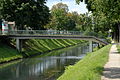
Motorway Railway Bridge

Actually two concrete bridges standing side by side for the motorway feeder to the southern motorway, which was opened in 1972, as well as the parallel railway towards Wörthersee, under which Villacher Straße, Lendkanal and Tarviser Straße are led. On the north side the bridge piers were approved by the city for painting with graffiti .

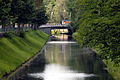
Stone bridge
The Stone Bridge is the oldest bridge over the Lend Canal. It was built in 1535 and is therefore probably the oldest surviving bridge in Carinthia . It was the only connection between the localities and today's Klagenfurt districts of Waidmannsdorf and St. Martin . The bridge is built from rubble stones, its half-arch is completed by the reflection in the dark water to a full round arch. In 1966 it had to be adapted to meet modern traffic requirements and expanded to a width of 13.5 meters, without damaging its unique character. In summer, the Stone Bridge is a popular meeting place for young people on their way from the city to the lake.
Heinzelsteg
An unspectacular pedestrian bridge from 1962. Named after Julius Heinzel, former director of the Klagenfurt grammar school and state school inspector.
Paternion Bridge
Alongside the Stone Bridge, the Paternion Bridge is the most important crossing point for road traffic. It got its officially not established name from the neighboring, no longer existing Gasthaus Paternioner. The Villacher Straße, one of the main connecting roads in Klagenfurt, leads over it, and below it the cycle path towards Wörthersee leads. The Paternion Bridge was originally made of wood and had to be reinforced in 1910, otherwise it would not have had enough load-bearing capacity for the electric tram. Between 1946 and 1950, a temporary bridge in the immediate vicinity was used for traffic during the new construction of the Paternion Bridge.
Lorelpeg (cycle path)
The cycle path at Minimundus is close to the University of Klagenfurt, the planetarium and the reptile zoo.
Heinzelsteg from 1962
Paternion Bridge

Lorelpeg - east view


Wörthersee-Süduferstraße
Between Minimundus and Europapark, the Wörthersee-Süduferstraße leads over one of the three Lendkanal car bridges from Villacher Straße to Maiernigg. Before it was built, the Süduferstraße began at the Paternion Bridge. This bridge has been expanded to four lanes since 2007.
Lorettosteg (Metnitzstrand-Steg)
This covered wooden walkway connects the Metnitz beach - named after the former mayor Gustav Ritter von Metnitz - with the opposite Wilsonstraße. It was rebuilt in the 1990s and is the last crossing over the canal before Maria Loretto. The Lendcanaltramway and the city traffic and cinema museum are in the immediate vicinity .

Lorettosteg


literature
- Siegfried Hartwagner: Klagenfurt city . Neuer Kaiser Verlag, Klagenfurt 1994.
- Trude Polley: Klagenfurt. From the Zollfeld to the Wörthersee . Paul Zsolnay Verlag, Vienna 1973, ISBN 3-552-02537-5
- Hermann Th. Schneider: The streets and squares of Klagenfurt . State capital Klagenfurt, year of publication unknown.
Web links
Coordinates: 46 ° 37 '23 " N , 14 ° 17' 57" E