Liesing (Lesachtal municipality)
|
Liesing ( village ) locality ( capital of the community ) Liesing cadastral community |
||
|---|---|---|
|
|
||
| Basic data | ||
| Pole. District , state | Hermagor (HE), Carinthia | |
| Judicial district | Hermagor | |
| Pole. local community | Lesachtal | |
| Coordinates | 46 ° 41 ′ 33 " N , 12 ° 48 ′ 58" E | |
| height | 1044 m above sea level A. | |
| Residents of the village | 108 (January 1, 2020) | |
| Building status | 56 (2001) | |
| Area d. KG | 52.29 km² | |
| Statistical identification | ||
| Locality code | 00421 | |
| Cadastral parish number | 75106 | |
| Counting district / district | Liesing (20321 002) | |
| Source: STAT : index of places ; BEV : GEONAM ; KAGIS | ||
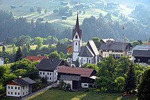
Liesing is a village in the Lesachtal municipality in Carinthia .
The clustered village of Liesing in the Lesachtal is 1043 m above sea level and has 130 inhabitants (2001). The municipal office of the Lesachtal municipality is located in Liesing. Until 1973 Liesing was an independent political municipality, then the place was merged with Maria Luggau , Birnbaum and Sankt Lorenzen as part of the municipal structural reform .
Culture and sights
- Parish church hl. Nicholas
- Wayside shrine
- Rural Paarhöfe and Mauerspeicher
- The place is located near the 5 wheel mills in Maria Luggau and the double wheel mill Wachterbachmühle in the hamlet of Tiefenbach on the border with East Tyrol.
literature
- Bundesdenkmalamt (Ed.): Dehio manual. The art monuments of Austria: Carinthia. Liesing. Verlag Anton Schroll & Co, third, expanded and improved edition, Vienna 2001, p. 467f, ISBN 3-7031-0712-X .
Web links
Commons : Liesing (Lesachtal) - Collection of images, videos and audio files

